
The prettiest small villages within 90 minutes of Roma

Rome sits in a basin ringed by hills, and the villages on those hills are built from what the ground gave them: grey limestone in the Prenestini, honey-brown tufa where the old volcanoes left their craters, chestnut beams in the Sabine uplands. Spring brings broom and wild asparagus along the verges, autumn brings porcini, chestnuts roasted in the piazza and the first pressing of the local olives, which in Sabina is thin, green and peppery enough to stand alone on bread. The cooking is unshowy and close to the ground, fettuccine with hare, coratella with artichokes, ricotta from sheep that still walk the drove roads. Most of these places are a single climb of narrow lanes ending at a castle keep or a belvedere with the whole plain of the Tiber laid out below.
Almost everyone with a spare day and a hire car goes to Tivoli. Villa d'Este and Hadrian's Villa are worth the queue, and the queue is real, coaches from the city arriving through the morning and the ticket line running along the wall by midday. The town itself absorbs the overflow, so the restaurants near the gate cook for people who will not return. Frascati and the wine towns of the Castelli do the same job on Sundays, filling their cellars with Romans out for lunch.
The same hills carry on past Tivoli in every direction, and they get quieter fast. East into the Monti Prenestini and the Lucretili, north into the Sabina, south to the wooded crater above the lake, the villages thin out and the roads narrow. Fewer people go, which is mostly a matter of the coaches not fitting. All of the places here have passed the national assessment of Italy's most beautiful villages, and all of them sit inside an hour and a half of the city.
Of the 30 communes we have mapped within 90 minutes of Roma, 12 qualify as prettiest villages: each has passed the national assessment of Italy's most beautiful villages. This list is the small ones, 6 in all, ordered smallest first. The smallest, Percile, has 219 residents.
If you are still choosing, we have also written The prettiest villages in the province of Roma and The best hidden mountain towns within 90 minutes of Roma.
Percile
Why visit Percile
Percile sits sixty kilometers from Rome, on the border between the Roma and Rieti provinces. The name derives from gens Porcia, a Roman family of the area, and the earliest documented evidence of habitation dates between 314 and 335, in the biography of Pope Sylvester I.
The village occupies the rocky spur itself, walled stone houses and vaulted passages built to the shape of the ground; above it the slopes rise into oak and beech woods that belong to the wider park, climbing toward Monte Pellecchia. The relation between the two levels is the whole of the place: the settlement below, compact and defensible on its spur, and the water held above it in limestone basins fed by underground springs.
What the borgo protected on the ground, the park has protected in the hills. The population today is 219, spread across a comune territory of 24 square kilometers, which makes Percile a small fixed point inside a much larger stretch of protected woodland.
What to see in Percile
- Lagustelli di Percile. The walk up from the village runs through oak forest and ends at clear water held in two limestone basins between 674 and 704 meters, filled by underground springs.
- Centro storico. Medieval stone village on a rocky spur, with vaulted passages, surviving gates and the panorama from the upper terrace.
- Parco Naturale dei Monti Lucretili. Regional park covering oak and beech woods on the karst slopes around the village, with marked trails to the lakes and toward Monte Pellecchia.
How to get to Percile
Roma is roughly 54 minutes away by road.
Our tip
April through June and September through October are the best months at 575 meters. The Lucretili woods are green into June and the walks up to the Lagustelli are at their best when the karst basins are full from spring rain. July and August are workable; the village stays cooler than Rome forty kilometers downhill, but the open trails go silent in midday heat.
Capranica Prenestina
Why visit Capranica Prenestina
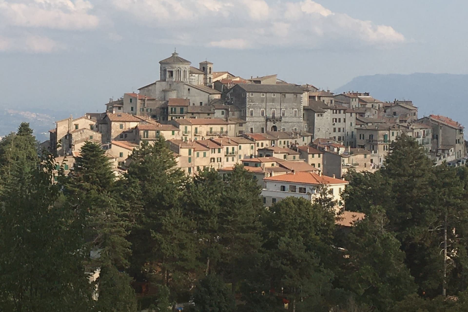
The Monti Prenestini are a small sub-Apennine range east of Rome, with Castel San Pietro Romano and Palestrina anchoring the southern flank and Capranica Prenestina set higher on the ridge above them. The village has three hundred residents and one institutional signal, the Borghi più belli d'Italia membership it received in 2024.
Beech forest covers the slopes above the houses, and the ground beneath is karst, the subject the civic museum in the old Barberini residence was built to explain. Above it all, in the frazione of Guadagnolo, the Mentorella sanctuary sits at 1,018 meters below Monte Guadagnolo itself, and tradition ties its founding to Constantine in the fourth century; Pope John Paul II went there as cardinal and as pope.
The village is half an hour by car from Tivoli, the via Empolitana threading through the woods between them. A small ridge settlement, then, with its natural history collected in a converted palace at its center and its oldest sacred site set apart on the mountain above it, the two poles, civic and devotional, that the range holds together.
What to see in Capranica Prenestina
- Santuario della Madre di Dio alla Mentorella. The sanctuary stands on a cliff, managed today by the Polish Resurrectionist order.
- Palazzo Barberini. The residence's rooms now hold the civic natural history collection, the grandest building the centro storico has.
- Museo Civico Naturalistico dei Monti Prenestini. Civic natural history museum dedicated to the karst geology, beech forests and fauna of the surrounding range.
How to get to Capranica Prenestina
Roma is roughly 70 minutes away by road.
Our tip
May through September is the working window. At 915 meters the village stays ten degrees cooler than Rome and the beech forests on the slopes above are walkable through August. October still holds for the autumn light on the Aniene valley and for the pilgrim traffic up to Mentorella.
Collalto Sabino
Why visit Collalto Sabino
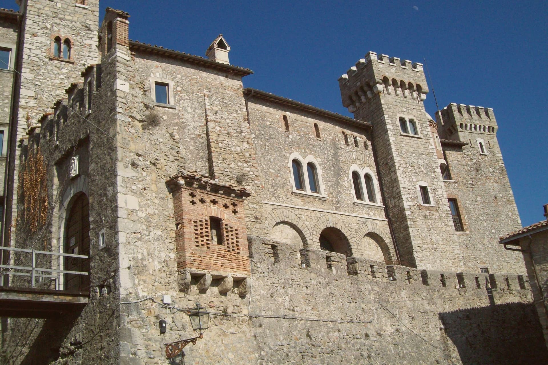
The name preserves Collis Altus and the family who first held the hill. Lombards established the village in the tenth century; the Savelli, Strozzi and Soderini families held it in turn before the fief passed to Cardinal Francesco Barberini in 1641.
The castle on the summit is the result of his work and that of his nephew Francesco Barberini junior, who enlarged the keep, fortified the walls and built dungeons inside the rock. It has a central square tower, two round corner towers and a curtain of watchtowers and sentry posts.
The village sits at 980 meters northeast of Rome, walled since the fifteenth century, with the fortress set above the stone houses and the older settlement gathered under it on the slope, narrow stairs and panoramic alleys threading between them. Ownership of the fief changed hands for centuries, from Lombards through three baronial families, before the Barberini building campaign gave the place the fortified shape that has lasted: walls below, keep above, the two still reading as one structure from the approach, the panorama at the summit the reward for climbing through all of it.
What to see in Collalto Sabino
- Castello Baronale. Dungeons cut into the rock beneath the keep, watchtowers and sentry posts along the curtain wall, the work of Cardinal Francesco Barberini and his nephew after 1641.
- Centro storico. Stone houses reached by narrow stairs, alleys that open onto the panorama below the castle walls.
- Panorama from the keep. The terrace view takes in Gran Sasso, Terminillo and Maiella at once, the three highest ranges of the central Apennines standing in a single arc from the same point.
How to get to Collalto Sabino
Roma is roughly 65 minutes away by road.
Our tip
May through September is the window the castle and the village were built around. At 980 meters the air stays clean in midsummer when Rome fifty-five kilometers downhill is hitting thirty-five, and the three-range panorama opens longest after spring rain clears the haze. October still holds for the woods of the Monte Navegna reserve turning copper and for short walks toward Lago del Turano below.
Orvinio
Why visit Orvinio
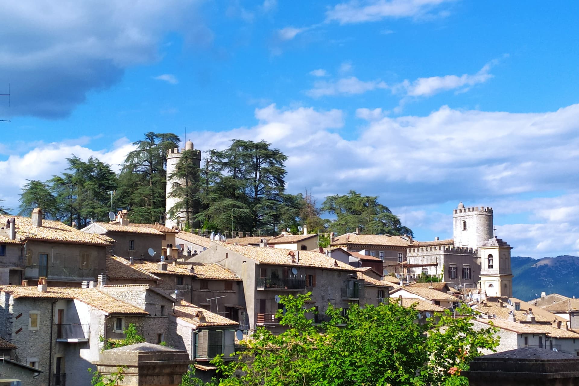
Orvinio sits on a saddle in the Monti Lucretili park, the last village before the slopes drop toward the Turano lake. The ancient settlement called Orvinium was destroyed before the year 1000, and the medieval town that grew up afterward took the name Canemorto, said to commemorate a Saracen defeat by Charlemagne's troops in 817.
The Orsini built the Granarone palace in the fifteenth century, before the Borghese took the fief in 1632. The village they governed still reads in two layers: stone houses running in tight loops below the ridge, and the Castello Malvezzi-Campeggi above them, the physical record of who held the place longest.
The Cammino di San Benedetto crosses this lower town on its way between Subiaco and Norcia, a reminder that the village has always been a point of passage as much as a seat of lordship. What remains is a settlement whose name changed twice and whose skyline did not: the castle above, the loops of houses below, unchanged in relation even as the village below it was renamed.
What to see in Orvinio
- Castello Malvezzi-Campeggi. Rebuilt by the Borghese in the nineteenth century, it dominates the village from the upper ridge, still visibly the seat of the family that held the fief the longest.
- Abbazia di Santa Maria del Piano. Benedictine abbey founded in the early Middle Ages, the original landlords of the territory before the Orsini took it.
- Centro storico. Stone houses in tight medieval loops below the castle, with vaulted passages and the original village gates preserved.
How to get to Orvinio
Roma is roughly 60 minutes away by road.
Our tip
May through September is the working window at 840 meters. The Lucretili woods open, the trails dry out and the village evenings stay cool when Rome forty-five kilometers downhill is hitting thirty-five. October still holds for the woods turning copper and for the Cammino di San Benedetto walkers passing through on the route between Subiaco and Norcia. Sagra della Polenta falls in August.
Castel San Pietro Romano
Why visit Castel San Pietro Romano
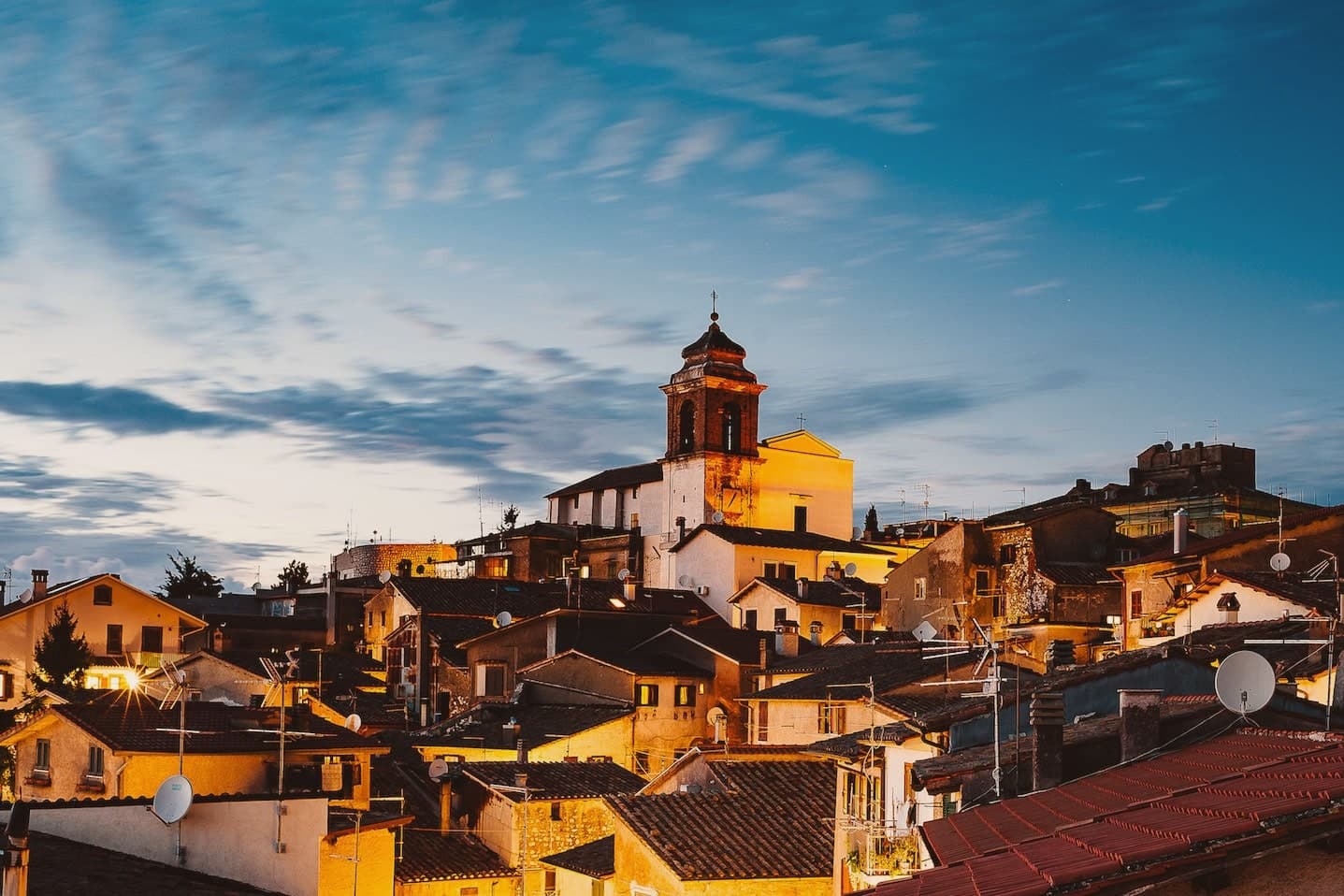
The hilltop sits three kilometers above Palestrina and forty east of Rome, and has been inhabited since the late Bronze Age. The acropolis of ancient Praeneste, the Latin city known for the sanctuary of Fortuna Primigenia, occupied this same ground before the medieval village grew inside it, which is why cyclopean walls from that earlier phase still ring the upper settlement built centuries later.
In the twelfth century the Colonna raised a castrum here for defensive control over Palestrina below. It was destroyed in 1298 and rebuilt twice over the following two centuries, then restored again in 1482, after which it lost its military role entirely and served the community as a grain store.
The village also saw the 1848 Battle of Palestrina, when Garibaldi's Roman Republic troops fought soldiers of the Kingdom of the Two Sicilies on these slopes, and later lent its streets and terraces to Wyler's cameras before the Borghi più belli d'Italia membership followed. What stands today is a single hill occupied twice over, once for a Latin acropolis and once for a Colonna stronghold, with the second built directly on the bones of the first.
What to see in Castel San Pietro Romano
- Rocca Colonna. The fortress on the summit of Monte Ginestro stands over the grain store it became after Stefano Colonna's 1482 rebuilding; the walls that face Palestrina still carry the bulk of a structure built for defense, not storage.
- Cyclopean walls of Praeneste. Pre-Roman polygonal masonry from the Latin acropolis, sections still visible inside the medieval village.
- Chiesa di San Pietro Apostolo. Parish church enlarged in 1732 under Clement XII on a project by Nicola Michetti, replacing an earlier thirteenth-century structure.
How to get to Castel San Pietro Romano
Roma is roughly 57 minutes away by road.
Our tip
May through September is the strongest window. The 763-meter altitude takes the edge off Roman summer heat and the view from the castle terrace opens cleanest in late spring and early autumn. October holds for the autumn light over the Sacco valley and the Lepini ridges. Festeggiamenti Patronali San Rocco falls in July.
Nemi
Why visit Nemi
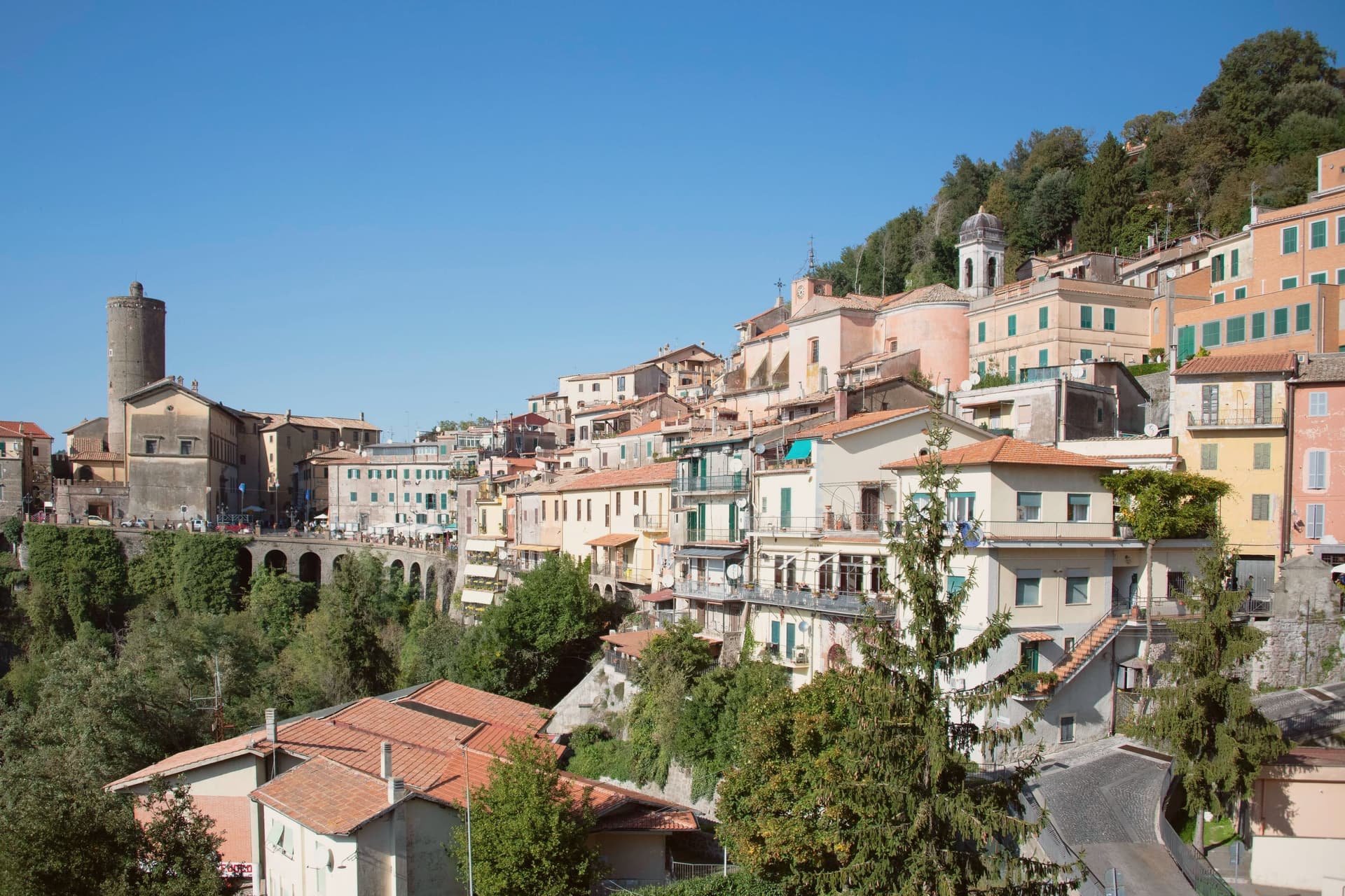
Nemi sits at 521 meters on the rim of a volcanic crater, the smallest of the Castelli Romani and thirty kilometers southeast of Rome. The lake below was the Speculum Dianae, the mirror of Diana, with a sanctuary on its northern shore that covered around 45,000 square meters and drew pilgrims from across Latium.
Emperor Caligula built two ceremonial ships on the lake, ninety meters of timber and bronze that sat on the water until they sank. Mussolini drained part of the lake between 1929 and 1932 to recover them.
They were destroyed by fire in 1944, almost certainly by retreating German troops. The Museo delle Navi Romane, built in 1940 to hold them, now shows scaled reconstructions and salvaged fragments.
Palazzo Ruspoli, a ninth-century castle restored by Valadier, anchors the centro storico. The wild strawberries grown on the inner slopes of the crater are sold from stalls along Via Roma and celebrated each June at the Sagra delle Fragole.
What to see in Nemi
- Palazzo Ruspoli. Ninth-century castle of the Counts of Tuscolo, restored by Valadier, with cylindrical tower and hanging garden over the lake.
- Museo delle Navi Romane. Lakeshore museum built in 1940 for Caligula's two recovered ships, destroyed by fire in 1944, now housing scaled models and fragments.
- Santuario di Diana Nemorense. Remains of the federal sanctuary on the lake's northern shore, once 45,000 square meters of temple, porticoes and theater.
How to get to Nemi
Roma is roughly 52 minutes away by road.
Our tip
April through June and September into October are the dry months on the crater rim, when the wild strawberries ripen and the lake holds its color. The Sagra delle Fragole runs the first Sunday of June and draws thousands. July and August push the basin into the low thirties; the centro storico stays cooler at 521 meters than the coast or the city, but weekends fill with day-trippers from Rome. Borgo diVino in tour falls in September.
More from Anywhere Italy
- The prettiest villages in the province of Roma
- The best hidden mountain towns within 90 minutes of Roma
- The prettiest villages inside a nature park within 90 minutes of Roma
 The best mountain towns in Lazio
- The best mountain towns within 75 minutes of Rome
- The best small towns inside a nature park in Lazio