
The best mountain towns within 90 minutes of Perugia
East and south of Perugia the ground rises fast. Roads climb through oak and then beech, past sheep folds and abandoned threshing floors, into villages built of the same grey limestone as the ridge they sit on. Autumn is the season that makes sense of this country: chestnuts roasting in village squares, lentils and farro in the soup, pecorino aged in the cellar, wild boar on Sunday. Winter brings snow and woodsmoke, and in late spring the high meadows above the treeline flower for a few short weeks.
Most visitors to this part of Italy point the car at Assisi, and the basilica absorbs coach after coach from spring to late October. Spoleto and Norcia take the overflow, the second on the strength of its cured meat counters and the mountains behind them. The result is that a handful of famous names carry almost all the traffic while the ranges they sit beneath stay quiet, even in high summer when the Sibillini are at their best.
The same limestone continues, though. Past the well-known towns the mountains keep going, up into the Valnerina, over into the Rieti basin and east into the Marche foothills below the Sibillini peaks. The towns here are smaller, some of them very small, with a bar, a church worth stopping for and a road that ends at a pass. Fewer people go, and all of them are within a morning's drive of Perugia.
Of the 73 communes we have mapped in a 90-minute drive of Perugia, 6 qualify as mountain towns: each sits in the mountains proper. The smallest, Labro, has 355 residents.
Elsewhere in the catalogue: The 6 best mountain towns within 90 minutes of Terni and The best towns known for what they grow within 90 minutes of Perugia.
Labro
Why visit Labro
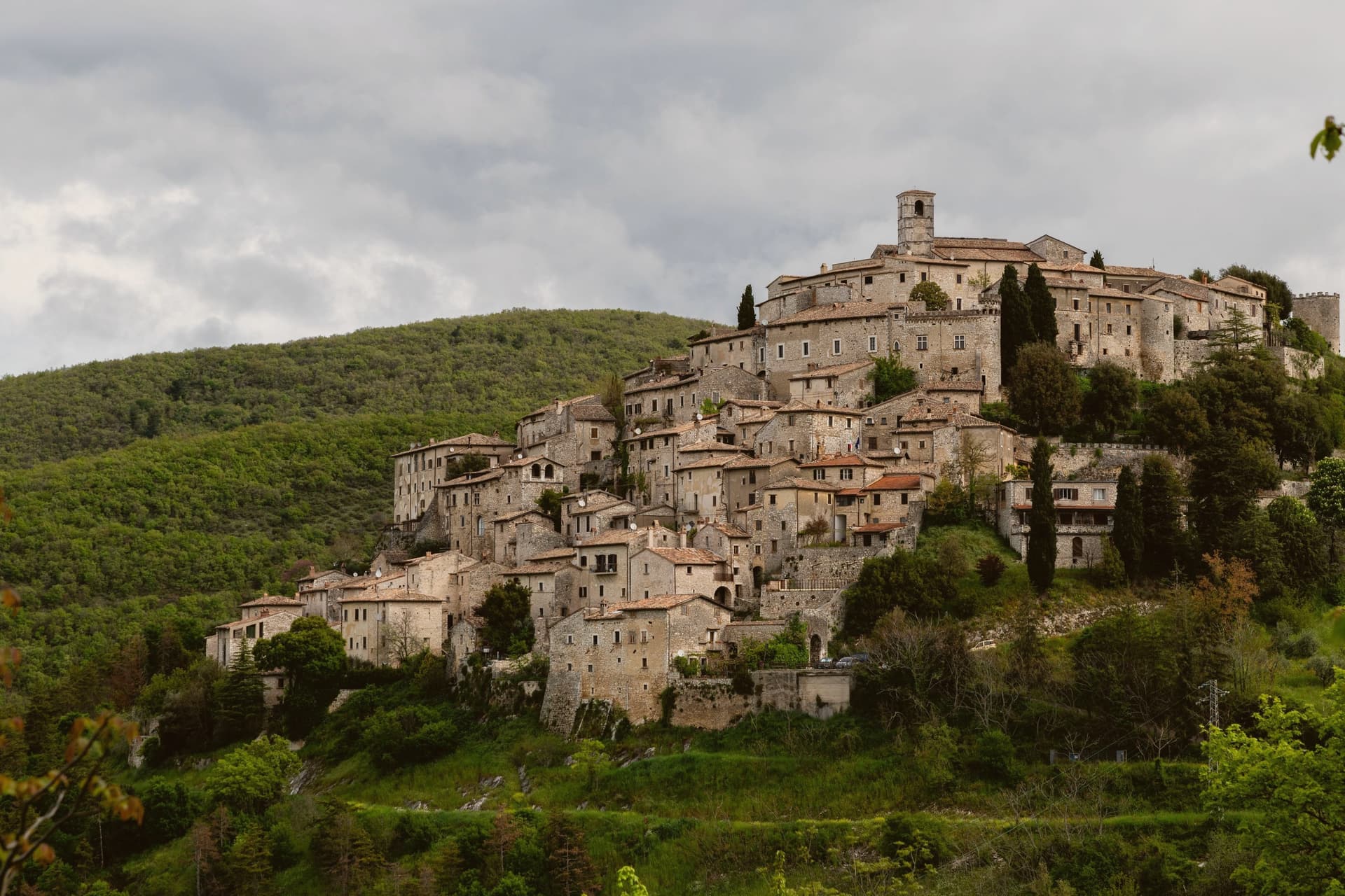
The village sits on the Lazio side of the Umbrian border, its stone houses climbing a slope that faces east over Lake Piediluco and the Reatini mountains. The name descends from the family that has held the central castle for more than a thousand years, an unbroken tenure from a royal grant to the present owners' later dynastic name.
That family shaped the top of the village around the castle and the church below it; the rest of the centro storico, some twelve hectares of stone houses, fell empty by the 1960s. The Belgian architect who began buying and restoring those houses did so with his wife, and the project passed to his children, who still own and run much of the centro.
Two families, one holding the summit since the tenth century and one rebuilding the slope since the twentieth, account for nearly all of the village that stands today. Labro survived depopulation not by chance but by becoming, in effect, two long private restorations laid one above the other.
The village sits at 628 metres.
What to see in Labro
- Castello Nobili-Vitelleschi. The castle sits at the top of the village, reached by narrow stone alleys climbing from the lower gate. Still privately owned.
- Chiesa di Santa Maria Maggiore. Parish church on the main square of the centro storico, with works of devotional art collected by the family that has long held the castle above it.
- Belvedere su Lago di Piediluco. Eastern viewpoint at 628 meters dropping to Lake Piediluco at 375 meters, with the Reatini and Sabini ranges in the background.
How to get to Labro
Terni is roughly 26 minutes away by road.
Our tip
May through October is the working window. Spring brings green slopes and clear views down to Piediluco; autumn turns the surrounding woods. July and August push warm but the 628-meter elevation keeps nights cool, unlike the valley below.
Monteleone di Spoleto
Why visit Monteleone di Spoleto
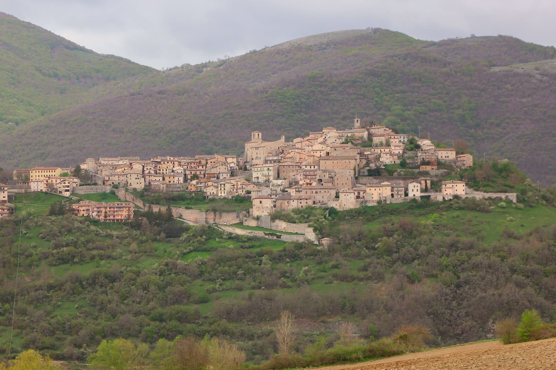
Monteleone sits at 978m on a hilltop in the upper Nera valley, the upper extension of the Valnerina, at the point where Umbria, Lazio and Marche converge. A castle anchors the summit and gives the borgo its defining silhouette, much-rebuilt over the centuries and again after the 2016 earthquake.
Below it sit the Chiesa and Convento di San Francesco, and the whole village is compact enough that the fortress organizes the view from almost anywhere within it. The find that put the town on archaeological maps happened by accident: a local farmer ploughing a field at the Colle del Capitano turned up an Etruscan bronze parade chariot in 1902, a complete biga from the 6th century BC.
His family sold it to French dealers for the equivalent of 950 lire, and it reached the Metropolitan Museum of Art in New York in 1903, where it is now displayed in Gallery 170 as the most complete pre-Roman parade chariot known to survive, its bronze panels depicting Achilles' birth, his combat with Memnon, and his apotheosis. Monteleone has pursued repatriation since 1990 through multiple legal proceedings, none successful, and the Met's title is now considered settled.
The village opened a museum in 2002 holding a full-scale replica alongside the original context of the find, and the town is also a marked stop on a 350-km pilgrim walk running from Norcia, Benedict's birthplace, through Monteleone to Subiaco and Montecassino, with pilgrim accommodation available locally. The 2016 Norcia and Cascia earthquake damaged several buildings in town; the castle and the Franciscan church have been restored, though reconstruction continues elsewhere.
Beyond the village, the Sibillini Mountains National Park lies to the east, the Cascia-Norcia route linking Benedict's and Rita's home towns runs to the north, and Lago di Piediluco is 30 km south. The food follows the Valnerina pattern: strangozzi with truffle, lentils from Castelluccio di Norcia, prosciutto and other Norcineria meats, pecorino, and Sagrantino di Montefalco from 60 km west.
Depopulation has been steep, from 1,800 residents in 1951 to 555 today, which leaves a village built for a much larger population now organized around a fortress, a church and a museum that all outsize the number of people currently living among them.
The village sits at 978 metres.
What to see in Monteleone di Spoleto
- Museo della Civiltà del Carro (replica chariot). Full-scale replica of the Monteleone Chariot, with the context of the 1902 find laid out around it. The panels on the original show Achilles' birth, his combat with Memnon, and his apotheosis. The museum also documents the village's repatriation campaign, active since 1990 and unsuccessful in every legal proceeding brought so far.
- Rocca dei Brancaleoni. The castle anchors the high point of the borgo, its rebuilt walls now standing again after 2016 earthquake repairs. From the top, the view runs across the whole upper Nera valley.
- Chiesa di San Francesco (Renaissance ceiling). 13th-century Franciscan church with later restorations and a carved wooden ceiling added in the 16th century. Also repaired after 2016 earthquake damage.
How to get to Monteleone di Spoleto
Terni is roughly 59 minutes away by road.
Our tip
Monteleone di Spoleto is mountain-seasonal — May through September is the high season. June-July brings the Cammino di San Benedetto pilgrim flow. Castelluccio di Norcia lentil bloom (late June-early July, 20 km east, the famous fiorita) is a major regional draw.
Sellano
Why visit Sellano
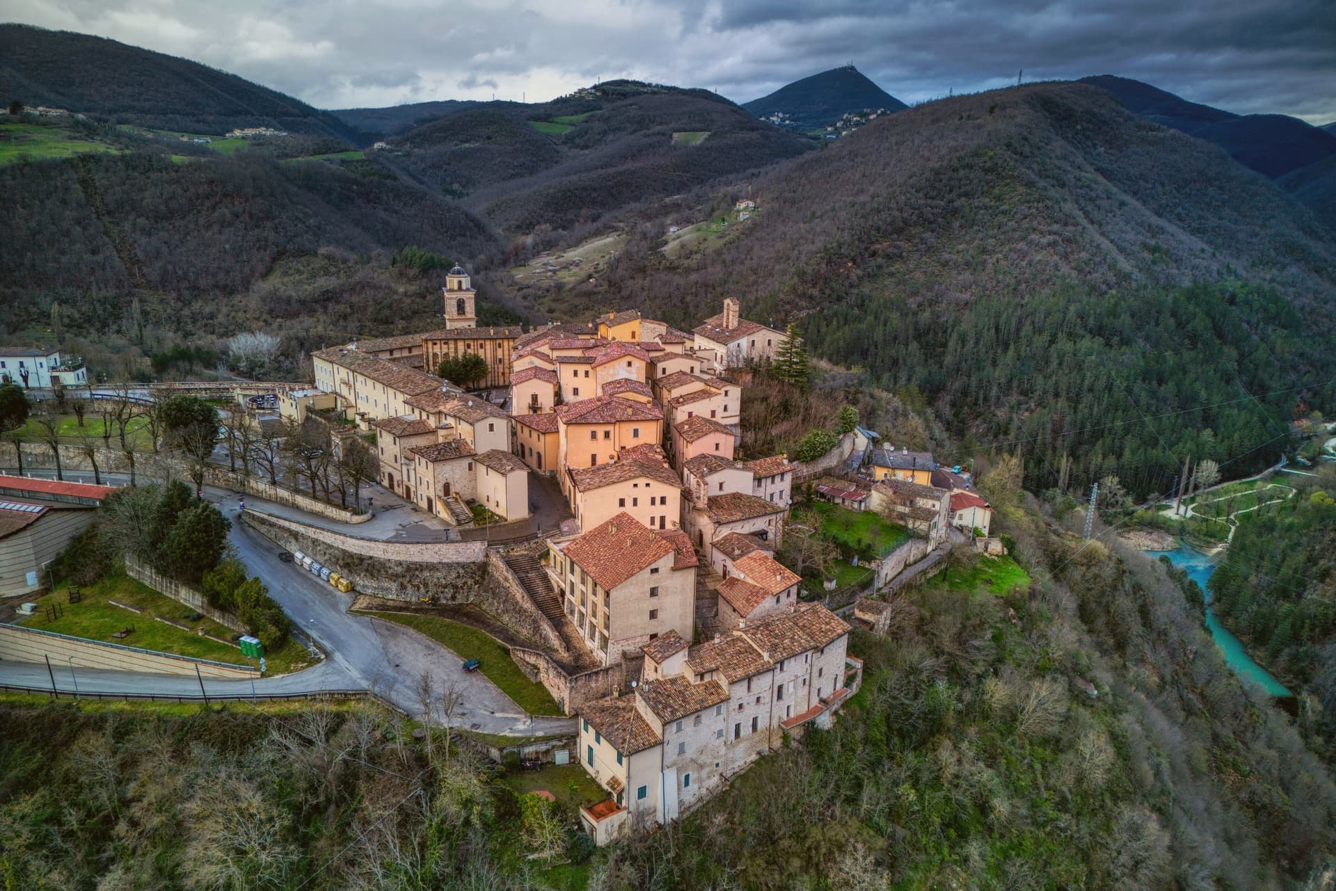
Sellano sits at 641 meters on the eastern edge of Umbria, looking over the Vigi stream toward the Marche border. The Vigi feeds the Nera; the valley is the upper Valnerina, one of the most isolated stretches of the Umbro-Marchigiano Apennines.
The 1979 and 1997 earthquakes hit the commune hard. The 1997 quake destroyed the sixteenth-century Palazzo dei Collicola at Montesanto and emptied most of the surrounding hamlets.
Reconstruction took two decades. In March 2024 a new structure opened: a 517-meter suspension footbridge across the Vigi gorge linking Sellano to the Castello di Montesanto, 175 meters above the valley floor, 1,023 steps, claimed as Europe's highest tibetan bridge alongside Portugal's Arouca 516.
Funded by NextAppennino, 1.6 million euros from PNRR earthquake-area development money. The bridge has become the visible decision of a small commune to bet its future on something other than waiting out emigration.
The village sits at 641 metres.
What to see in Sellano
- Ponte tibetano. 517-meter suspension footbridge opened March 2024, 175 meters above the Vigi gorge, 1,023 steps linking Sellano to Castello di Montesanto.
- Castello di Montesanto. Medieval fortress hamlet across the Vigi, depopulated after the 1997 earthquake, reachable on foot via the new bridge.
- Borgo medievale di Sellano. Compact walled centro storico looking east toward the Marche, partially rebuilt after the 1997 quake.
How to get to Sellano
Perugia is roughly 66 minutes away by road.
Our tip
May through October is the working season at 641 meters in the upper Valnerina. The new bridge runs full schedule, the trails along the Vigi gorge are open, and the temperature stays in the low twenties through summer afternoons. June and September are the best months for walking: long light, dry trail, late wildflowers. Sagra della Fojata e dell'Attorta falls in August.
Greccio
Why visit Greccio
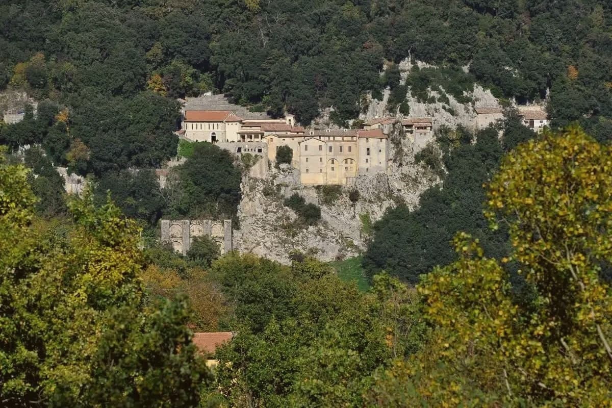
Greccio sits at 705 meters on a forested ridge above the Rieti valley, fifteen kilometers from Rieti in the Sabina. Francis of Assisi came here in December 1223, recalling his pilgrimage to Bethlehem fifteen years earlier, and asked the local lord Giovanni Velita for a cave where he could stage a representation of the Nativity.
On Christmas Eve the friars and villagers gathered in the rock chamber with a manger, an ox and a donkey; one of the friars said Mass and Francis preached. Greccio has been making versions of that scene every Christmas for eight centuries, and the Cappella del Presepio was built into the cave itself in 1228, the year of Francis's canonisation.
The medieval village runs along the ridge above the sanctuary, separated from it by the wooded slopes of the Monte Salto del Cieco reserve, so the walled center and the cave church remain two distinct places linked by a single climb through beech and oak woodland. Greccio is one of four shrines forming the Sacred Valley of Rieti, and the arrangement of a hilltop village standing apart from its own founding cave is what gives the place its shape: a settlement that grew beside a site it did not begin as, built to keep watch over a single night eight centuries old.
The village sits at 705 metres.
What to see in Greccio
- Santuario Francescano. Sanctuary built around the rock chamber where the manger, ox and donkey were assembled, its Cappella del Presepio carved directly into the cave wall.
- Museo Internazionale del Presepio. Crèches and presepi from cultures across the world, gathered inside the sanctuary complex.
- Centro storico medievale. Walled medieval village on the ridge above the sanctuary, with stone houses, vaulted passages and the original village gates.
How to get to Greccio
There is a railway station in the town, so you can arrive without a car and never need one while you are here. Terni is roughly 28 minutes away by road.
Our tip
May through September is the main outdoor window at 705 meters. The Rieti valley is green into June and the cool ridge stays workable through midsummer. October draws walkers for the autumn colour in the Salto del Cieco reserve.
San Ginesio
Why visit San Ginesio
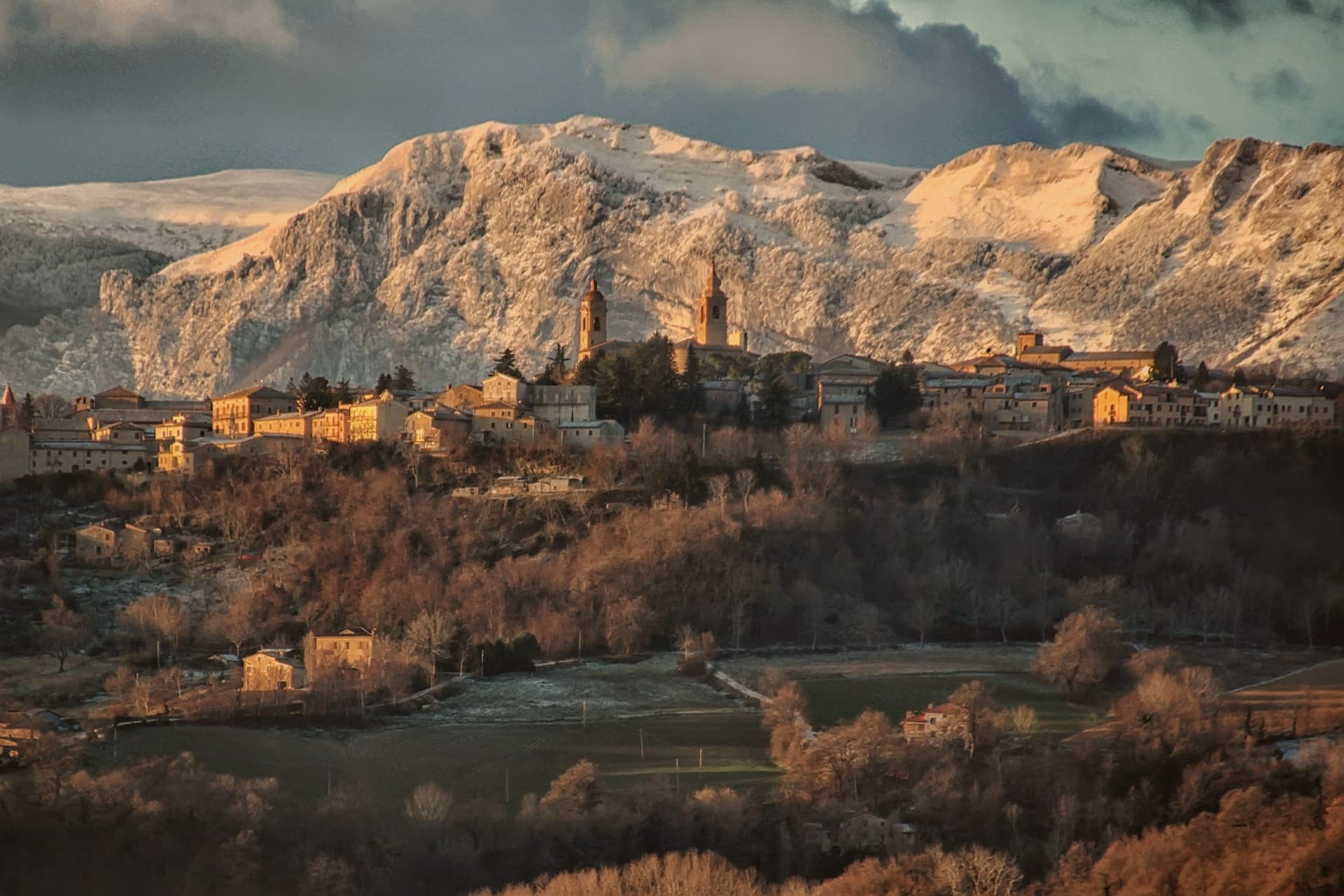
San Ginesio sits at 680 meters on a hill in the Macerata province, fifth highest commune in the province, on ground that Norman bourgeoisie first fortified in the tenth century to control the valley below. The town ran for a time as a free republic before joining the Papal States under Cardinal Albornoz's fourteenth-century constitutions, and it passed under the Da Varano of Camerino from 1355 to 1434.
A rivalry with the March of Fermo was settled at the Battle of Fornarina on 30 November 1377. The historic center gathers its civic and religious buildings around one square, the church, the hospital and the town hall standing within sight of each other, a layout that still reads as the working core of the old republic.
Outside the walls the ground rises toward the Sibillini massif, and the commune's territory reaches into the national park, so the same town that faces a piazza of medieval stone also has trails running from its western frazioni up into high pasture. The 2016 earthquake damaged many buildings and reconstruction is ongoing.
What the centuries of fortification, republic, and rivalry left behind is a hill town whose walls still look both ways: down over the valley it once controlled, and out toward the mountains that give it its name.
The village sits at 680 metres.
What to see in San Ginesio
- Collegiata della Santissima Annunziata. Fourteenth-century brick facade holds a Bernardino di Mariotto altarpiece inside. The building anchors one side of the square it faces.
- Ospedale dei Pellegrini. Sandstone columns with leaf capitals support the lower portico, an example of domus hospitales built along the pilgrim road. The brick loggia added above sits a century and a half later than the ground floor.
- Piazza Gentili. Central piazza of the centro storico, anchored by the Collegiata, the Palazzo del Comune and the Ospedale dei Pellegrini.
How to get to San Ginesio
Ancona is roughly 77 minutes away by road.
Our tip
May through October is the working window for San Ginesio. The Sibillini meadows turn green from May, the Balcony view reaches its clearest air through June and again in September, and the Battle of Fornarina commemoration runs each year on the last weekend of August. July and August touch the high twenties at 680 meters but the ridge breeze keeps the centro storico cool through the afternoons; the festa weekends fill Piazza Gentili. Fiera a San Liberato falls in August.
Camerino
Why visit Camerino
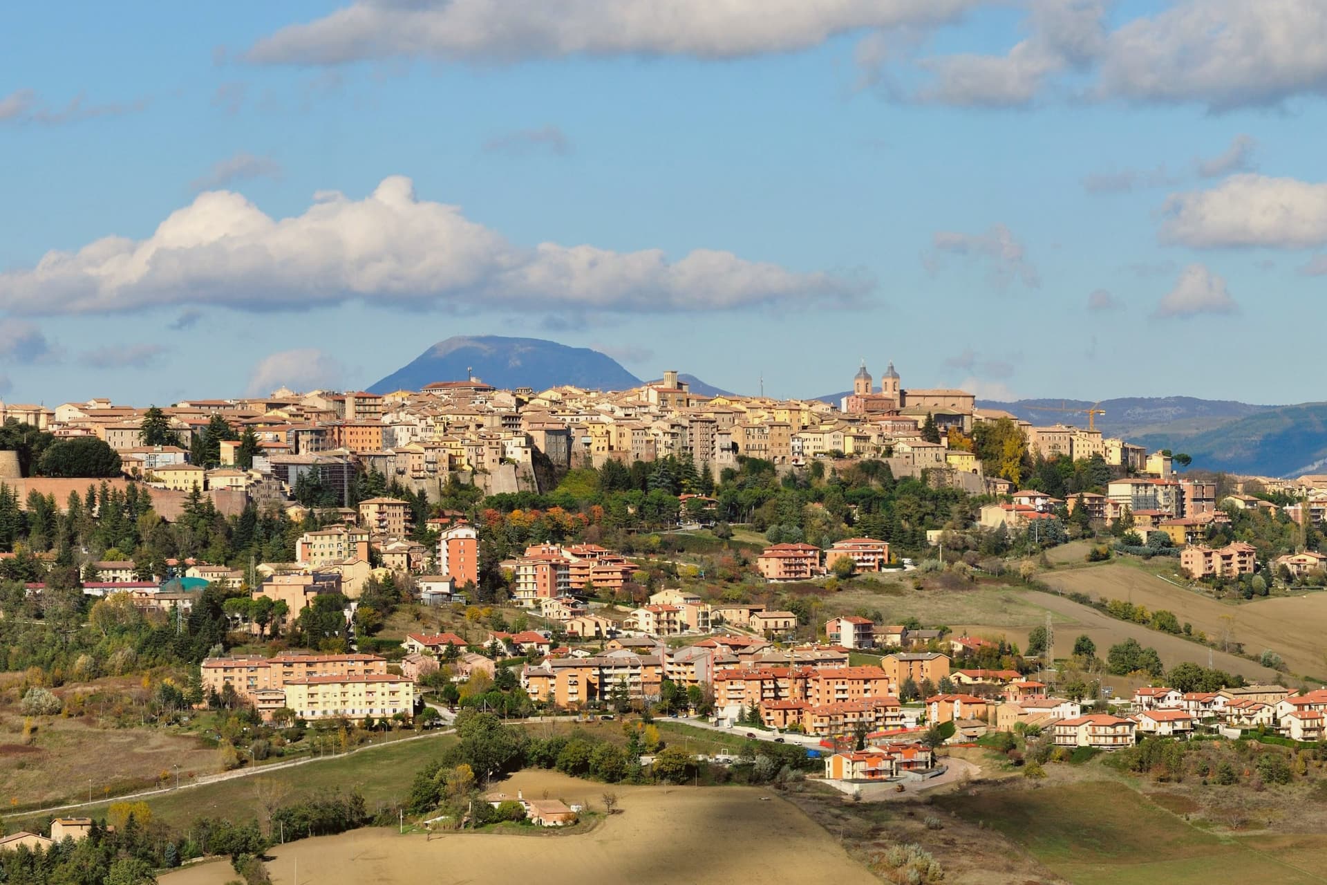
Camerino sits at 661 meters on a long ridge between the Chienti and Potenza valleys in the Marche Apennines, sixty-four kilometers from Ancona, the town strung along the high ground rather than gathered at its foot. The palazzo and the Rocca Borgesca, built in 1503 for Alessandro VI Borgia to a design by Lodovico Clodio, are joined by an underground passage, a defensive arrangement that ties the ducal residence to the fortress above it and speaks to how exposed the ridge position could feel despite its height.
The cathedral stands on Piazza Cavour alongside the Palazzo Comunale, the civic and religious centers of the centro storico set side by side rather than separated. The 30 October 2016 earthquake damaged most of the centro storico, the cathedral included, and the central square remains partly closed.
The university, older than the palazzi it now partly occupies, kept teaching through temporary quarters rather than closing. What the ridge town adds up to is a place where governance, faith and learning were built close together on purpose, and where that same closeness has kept the town functioning while the stone around it is still being put back.
The village sits at 661 metres.
What to see in Camerino
- Palazzo Ducale Da Varano. Completed in 1499 by Baccio Pontelli for Giulio Cesare Da Varano, on the model of Federico da Montefeltro's palace in Urbino, now part of the University.
- Rocca Borgesca. Built 1503 by Lodovico Clodio for Alessandro VI Borgia, connected underground to the palazzo, armed with forty-two cannon when complete.
- Cattedrale di Santa Maria Annunziata. Cathedral on Piazza Cavour, damaged by the 2016 earthquake, still in partial restoration; the Diocesan Museum holds artworks displaced from the nave.
How to get to Camerino
Perugia is roughly 76 minutes away by road.
Our tip
May through October is the working window for Camerino. The ridge holds long views to the Sibillini in spring and clears the surrounding hardwood forests into the high summer evenings. July and August stay cool at 661 meters; the university breaks and the festival weeks of the Corsa alla Spada and the Festa di San Venanzio fill the centro storico. Sagra della Panzanella falls in August.
More from Anywhere Italy
 The 6 best mountain towns within 90 minutes of Terni
 The best towns known for what they grow within 90 minutes of Perugia
- The best mountain towns in Lazio
- The best cheese towns within two hours of Perugia
 The 6 best small towns that eat well in the province of Perugia
 The best hidden towns on a walking route in the province of Perugia