
The 6 best mountain towns within 90 minutes of Terni
The land behind Terni climbs quickly. Within an hour the valley floor gives way to limestone ridges, beech forest and pasture, and the villages change with it, built low and heavy in grey stone with roofs of hand-cut tile. This is lentil and farro country, pork cured in cellars through the cold months, pecorino aged in ash, trout from rivers that run clear even in August. Spring brings wildflowers to the high meadows and autumn brings truffle and chestnut, and in winter the passes hold snow long after the plain below has dried out.
Most people driving out of Terni go to the Cascata delle Marmore, and then, if they carry on, to Norcia. Both earn their crowds. The falls are among the tallest in Europe and the coach parks fill by mid-morning; Norcia's shopfronts hung with hams and its rebuilt piazza draw a steady stream of visitors year-round. The road between them is well signposted and well travelled, and in high summer the queue for the viewing platforms can outlast the water release itself.
The same mountains keep going. Past the falls and beyond the Norcia plain, the ridges of the Reatino, the Valnerina and the Monti della Laga carry stone villages that see far fewer people, some of them within an hour of Terni's station. They sit above reservoirs, on the flanks of national parks, at the head of valleys where the road ends. The towns here are the smaller ones, still working, still cooking what the mountain gives them.
Of the 35 communes we have mapped within 90 minutes of Terni, 6 qualify as mountain towns: each sits in the mountains. The smallest, Castel di Tora, has 266 residents.
Two more lists worth reading alongside this one: The best mountain towns within 90 minutes of Perugia and The best mountain towns in Lazio.
Castel di Tora
Why visit Castel di Tora
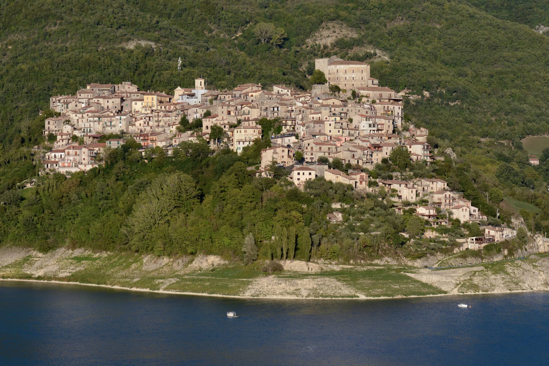
Castel di Tora sits at 607 meters on the northeast shore of Lago del Turano, in the upper Sabina, fifty kilometers northeast of Rome. The lake itself is artificial, dammed in 1936 for hydroelectric regulation of the Turano river; before then, two villages stood on the valley floor.
One of them, Antuni, gave up its houses and emptied. Today a small isthmus runs out to the Antuni promontory, where the fifteenth-century Palazzo del Drago, built with 365 windows for the days of the year, has been restored along with its garden labyrinth.
The medieval centro storico climbs the slope above the lake to a polygonal fortress tower of the eleventh century. The Monti Sabini close the western shore; the Carseolani close the eastern, rising to Monte Navegna at 1,508 meters.
Two hundred and sixty-six people live here year-round. The Cammino di San Benedetto passes through on its way from Subiaco to Rieti.
The village sits at 607 metres.
What to see in Castel di Tora
- Rocca medievale. Eleventh-century polygonal fortress tower on the cliff above the village, anchor of the original Castrum Vetus that gave the town its name.
- Antuni e Palazzo del Drago. Restored fifteenth-century palace with 365 windows for the days of the year, on the Antuni promontory across an isthmus, with a garden labyrinth.
- Lago del Turano. Artificial reservoir dammed in 1936 at 536 meters elevation, ten kilometers long, 60 meters deep, surrounded by the Sabini and Carseolani ranges.
How to get to Castel di Tora
Terni is roughly 72 minutes away by road.
Our tip
May through October is the season for Castel di Tora. The lake warms to swimming by late June, the Sabini stay green into August, and the chestnut woods on the slopes turn gold in October. July and August fill the lakeshore with day-trippers from Rome and Rieti, especially weekends.
Labro
Why visit Labro
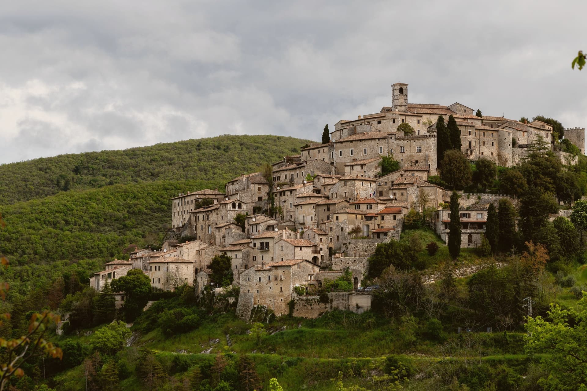
The village sits on the Lazio side of the Umbrian border, its stone houses climbing a slope that faces east over Lake Piediluco and the Reatini mountains. The name descends from the family that has held the central castle for more than a thousand years, an unbroken tenure from a royal grant to the present owners' later dynastic name.
That family shaped the top of the village around the castle and the church below it; the rest of the centro storico, some twelve hectares of stone houses, fell empty by the 1960s. The Belgian architect who began buying and restoring those houses did so with his wife, and the project passed to his children, who still own and run much of the centro.
Two families, one holding the summit since the tenth century and one rebuilding the slope since the twentieth, account for nearly all of the village that stands today. Labro survived depopulation not by chance but by becoming, in effect, two long private restorations laid one above the other.
The village sits at 628 metres.
What to see in Labro
- Castello Nobili-Vitelleschi. The castle sits at the top of the village, reached by narrow stone alleys climbing from the lower gate. Still privately owned.
- Chiesa di Santa Maria Maggiore. Parish church on the main square of the centro storico, with works of devotional art collected by the family that has long held the castle above it.
- Belvedere su Lago di Piediluco. Eastern viewpoint at 628 meters dropping to Lake Piediluco at 375 meters, with the Reatini and Sabini ranges in the background.
How to get to Labro
Terni is roughly 26 minutes away by road.
Our tip
May through October is the working window. Spring brings green slopes and clear views down to Piediluco; autumn turns the surrounding woods. July and August push warm but the 628-meter elevation keeps nights cool, unlike the valley below.
Monteleone di Spoleto
Why visit Monteleone di Spoleto
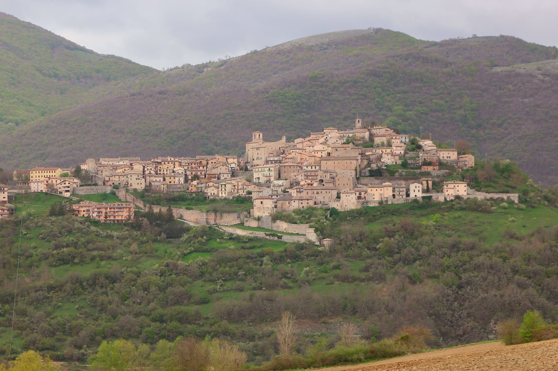
Monteleone sits at 978m on a hilltop in the upper Nera valley, the upper extension of the Valnerina, at the point where Umbria, Lazio and Marche converge. A castle anchors the summit and gives the borgo its defining silhouette, much-rebuilt over the centuries and again after the 2016 earthquake.
Below it sit the Chiesa and Convento di San Francesco, and the whole village is compact enough that the fortress organizes the view from almost anywhere within it. The find that put the town on archaeological maps happened by accident: a local farmer ploughing a field at the Colle del Capitano turned up an Etruscan bronze parade chariot in 1902, a complete biga from the 6th century BC.
His family sold it to French dealers for the equivalent of 950 lire, and it reached the Metropolitan Museum of Art in New York in 1903, where it is now displayed in Gallery 170 as the most complete pre-Roman parade chariot known to survive, its bronze panels depicting Achilles' birth, his combat with Memnon, and his apotheosis. Monteleone has pursued repatriation since 1990 through multiple legal proceedings, none successful, and the Met's title is now considered settled.
The village opened a museum in 2002 holding a full-scale replica alongside the original context of the find, and the town is also a marked stop on a 350-km pilgrim walk running from Norcia, Benedict's birthplace, through Monteleone to Subiaco and Montecassino, with pilgrim accommodation available locally. The 2016 Norcia and Cascia earthquake damaged several buildings in town; the castle and the Franciscan church have been restored, though reconstruction continues elsewhere.
Beyond the village, the Sibillini Mountains National Park lies to the east, the Cascia-Norcia route linking Benedict's and Rita's home towns runs to the north, and Lago di Piediluco is 30 km south. The food follows the Valnerina pattern: strangozzi with truffle, lentils from Castelluccio di Norcia, prosciutto and other Norcineria meats, pecorino, and Sagrantino di Montefalco from 60 km west.
Depopulation has been steep, from 1,800 residents in 1951 to 555 today, which leaves a village built for a much larger population now organized around a fortress, a church and a museum that all outsize the number of people currently living among them.
The village sits at 978 metres.
What to see in Monteleone di Spoleto
- Museo della Civiltà del Carro (replica chariot). Full-scale replica of the Monteleone Chariot, with the context of the 1902 find laid out around it. The panels on the original show Achilles' birth, his combat with Memnon, and his apotheosis. The museum also documents the village's repatriation campaign, active since 1990 and unsuccessful in every legal proceeding brought so far.
- Rocca dei Brancaleoni. The castle anchors the high point of the borgo, its rebuilt walls now standing again after 2016 earthquake repairs. From the top, the view runs across the whole upper Nera valley.
- Chiesa di San Francesco (Renaissance ceiling). 13th-century Franciscan church with later restorations and a carved wooden ceiling added in the 16th century. Also repaired after 2016 earthquake damage.
How to get to Monteleone di Spoleto
Terni is roughly 59 minutes away by road.
Our tip
Monteleone di Spoleto is mountain-seasonal — May through September is the high season. June-July brings the Cammino di San Benedetto pilgrim flow. Castelluccio di Norcia lentil bloom (late June-early July, 20 km east, the famous fiorita) is a major regional draw.
Preci
Why visit Preci
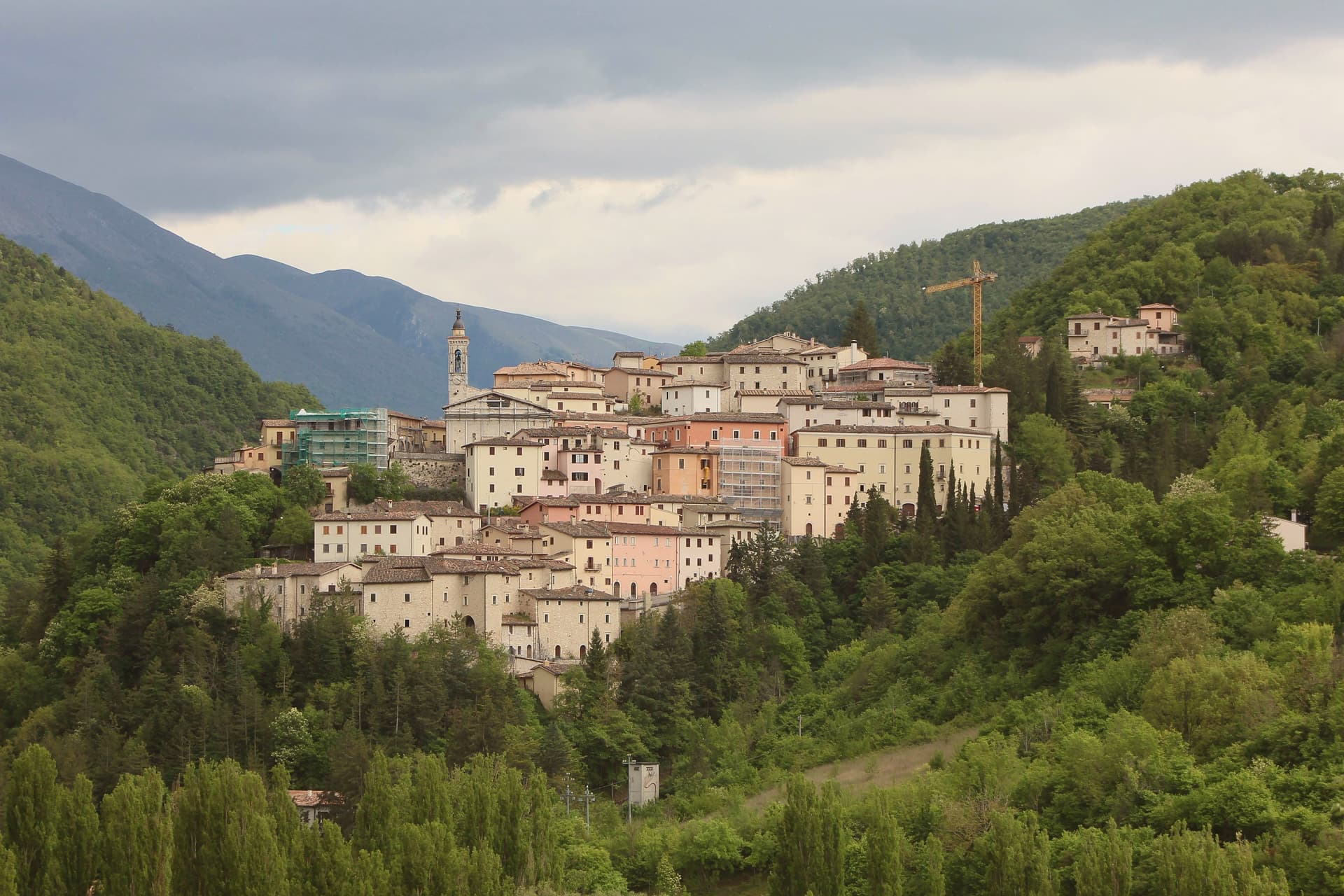
Preci sits at 596 meters in the Castoriana valley, inside the Monti Sibillini National Park and within driving distance of both Spoleto and Norcia. The walled borgo is crossed by the Campiano river and surrounded by mountain pasture.
The Abbazia di Sant'Eutizio, just outside the walls, is one of the oldest monasteries in Italy, founded by Syrian Benedictine monks in the fifth century. Their accumulated medical knowledge gave rise to the Preci school of surgery, which from the thirteenth to the eighteenth century supplied surgeons to royal courts across Europe; the local specialists worked in extraction of kidney stones, cataract surgery and hernia repair.
Noble palaces of the surgeon families still line the centro storico. The town was nearly destroyed by the 30 October 2016 earthquake, magnitude 6.5, which heavily damaged Sant'Eutizio; reconstruction is still in progress.
The Borghi più belli, Cittaslow and Parco Nazionale recognitions were retained through the rebuild.
The village sits at 596 metres.
What to see in Preci
- Abbazia di Sant'Eutizio. Benedictine monastery of 5th-century foundation, considered a place of origin for the Benedictine Order, heavily damaged in 2016 and under reconstruction.
- Centro storico fortificato. Walled medieval borgo on a hillside in the Castoriana valley, with noble palaces of the 16th-18th centuries built by the surgeon families.
- Museo della Scuola Chirurgica. Surgical school museum inside the Sant'Eutizio complex documenting the work of Preci surgeons from the 13th to 18th centuries.
How to get to Preci
Terni is roughly 90 minutes away by road.
Our tip
May through October is the working season at this elevation in the Valnerina. The Sibillini trails open in late spring and the Castoriana valley stays green through October. July and August are the months for the high trails to Piano Grande and Monte Vettore; the borgo itself stays cool in the upper twenties.
Greccio
Why visit Greccio
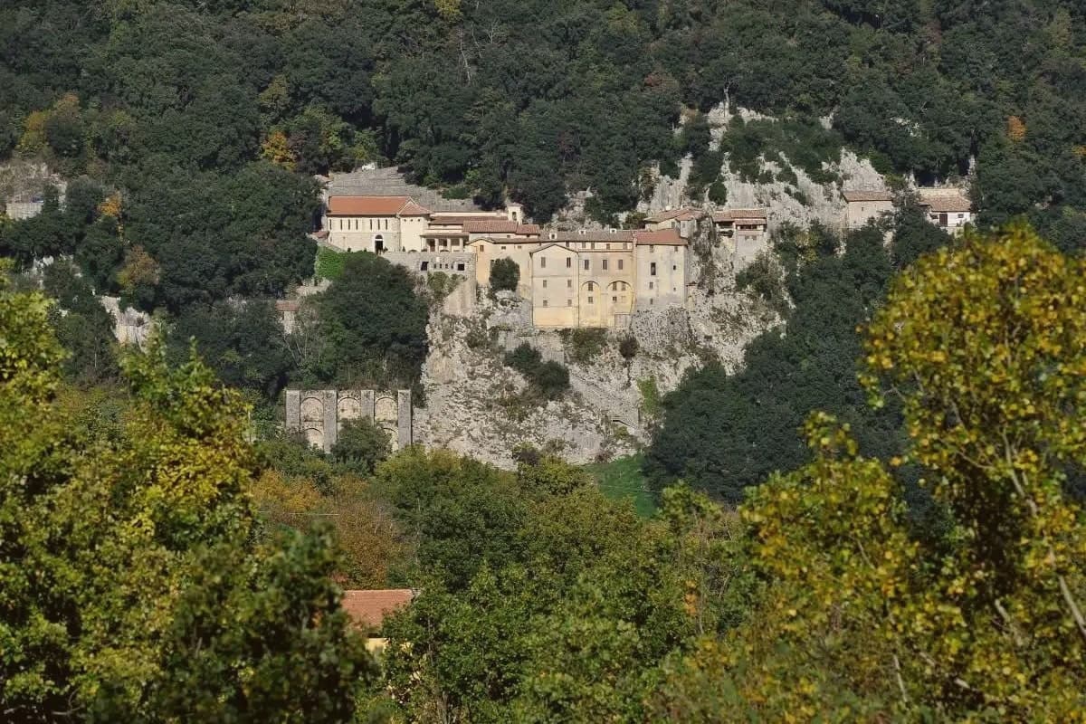
Greccio sits at 705 meters on a forested ridge above the Rieti valley, fifteen kilometers from Rieti in the Sabina. Francis of Assisi came here in December 1223, recalling his pilgrimage to Bethlehem fifteen years earlier, and asked the local lord Giovanni Velita for a cave where he could stage a representation of the Nativity.
On Christmas Eve the friars and villagers gathered in the rock chamber with a manger, an ox and a donkey; one of the friars said Mass and Francis preached. Greccio has been making versions of that scene every Christmas for eight centuries, and the Cappella del Presepio was built into the cave itself in 1228, the year of Francis's canonisation.
The medieval village runs along the ridge above the sanctuary, separated from it by the wooded slopes of the Monte Salto del Cieco reserve, so the walled center and the cave church remain two distinct places linked by a single climb through beech and oak woodland. Greccio is one of four shrines forming the Sacred Valley of Rieti, and the arrangement of a hilltop village standing apart from its own founding cave is what gives the place its shape: a settlement that grew beside a site it did not begin as, built to keep watch over a single night eight centuries old.
The village sits at 705 metres.
What to see in Greccio
- Santuario Francescano. Sanctuary built around the rock chamber where the manger, ox and donkey were assembled, its Cappella del Presepio carved directly into the cave wall.
- Museo Internazionale del Presepio. Crèches and presepi from cultures across the world, gathered inside the sanctuary complex.
- Centro storico medievale. Walled medieval village on the ridge above the sanctuary, with stone houses, vaulted passages and the original village gates.
How to get to Greccio
There is a railway station in the town, so you can arrive without a car and never need one while you are here. Terni is roughly 28 minutes away by road.
Our tip
May through September is the main outdoor window at 705 meters. The Rieti valley is green into June and the cool ridge stays workable through midsummer. October draws walkers for the autumn colour in the Salto del Cieco reserve.
Cascia
Why visit Cascia
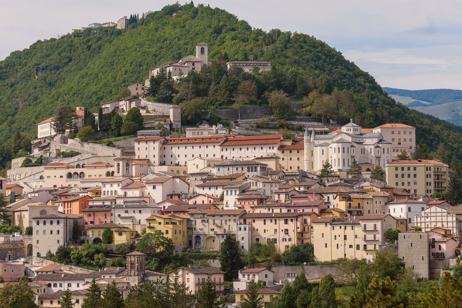
Cascia sits at 653 meters in the mountainous southeastern corner of Umbria, a remote pocket of the upper Valnerina near the Marche and Lazio borders. The commune carries the highest seismic activity in the region together with Norcia twelve kilometers away, and a long history of destructive earthquakes that culminated in the August 2016 sequence.
The town is built around Rita Lotti, who died in the Augustinian monastery here in 1457 and was canonized as Santa Rita in 1900. The Basilica di Santa Rita, built 1937-1947 in white Tivoli travertine on the site of the older church, draws pilgrims year-round and turns Cascia into a town that runs on faith and on truffle.
The Cammino di San Benedetto passes through, linking Norcia to Subiaco and Montecassino. Visitors not pilgrims tend to come for the black truffle, the lentils of nearby Castelluccio, and the silence of the high pastures above town.
The village sits at 653 metres.
What to see in Cascia
- Basilica di Santa Rita. Built 1937-1947 in white Tivoli travertine, Greek-cross plan, frescoes by Montanarini, Filocamo, Consadori, Ceracchini and Vicenzi.
- Monastero di Santa Rita. Augustinian monastery where Rita Lotti lived and died in 1457, attached to the basilica and still active as a religious community.
- Chiesa di San Francesco. Medieval Franciscan church in the lower centro storico, fourteenth and fifteenth-century frescoes inside.
How to get to Cascia
Terni is roughly 74 minutes away by road.
Our tip
May through October is the open season at 653 meters. The basilica is busiest around the May 22 feast of Santa Rita, when pilgrims fill the upper town and accommodation books out months ahead. June through September brings mild days and cool nights, the high pastures green, the truffle hunters working the woods above town.
More from Anywhere Italy
- The best mountain towns within 90 minutes of Perugia
- The best mountain towns in Lazio
- The best cheese towns within two hours of Perugia
 The best hidden towns on a walking route in the province of Perugia
- The 8 best hill towns on a walking route within 90 minutes of Terni
- The prettiest villages that eat well within 90 minutes of Terni