
Day trips
Day trips from Potenza
20 towns within 90 minutes
Closest first. Sant'Angelo Le Fratte is 38 minutes out. Drive times are computed on real roads, so they are a fair estimate rather than a promise about traffic.
The towns
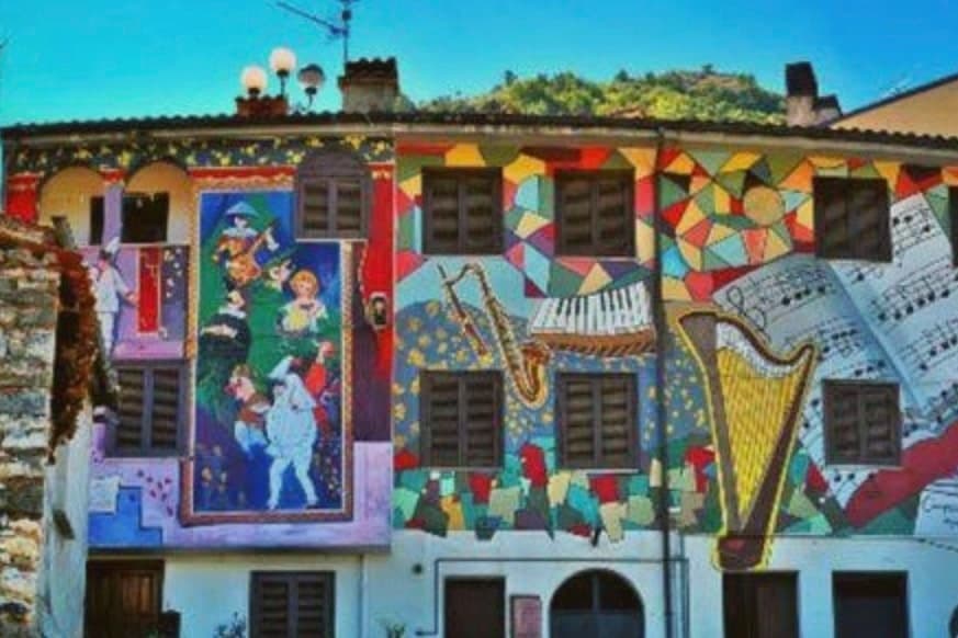
Sant'Angelo Le Fratte
Province: Potenza · 560 m
38 minutes from Potenza. A village of 1,315 in the Melandro valley whose house fronts are painted with trompe l'oeil murals, so that a real balcony sits beside a painted one and a woman in old Lucanian dress leans out of a wall.
Sasso di Castalda
Province: Potenza · 949 m
38 minutes from Potenza. A 949-meter village in the Lucanian Apennines whose emigrants produced the engineer who launched Apollo 11, now crossed by a 300-meter Tibetan footbridge.
Acerenza
Province: Potenza · 833 m
40 minutes from Potenza. A walled ridge town at 833 meters in the north Lucanian hills, archbishopric since 1068 under a Romanesque cathedral begun in 1080.
Castelmezzano
Province: Potenza · 750 m
43 minutes from Potenza. A medieval village wedged into sandstone teeth at 750 meters, linked to Pietrapertosa by a zipline of about 1.4 km since 2007.
Calvello
Province: Potenza · 730 m
47 minutes from Potenza. A 730-meter ceramic town working clay since 1200, when Benedictines from Faenza brought the wheel south.
San Fele
Province: Potenza · 872 m
47 minutes from Potenza. A stone village at 872 meters between two peaks, where a 969 fortress and ten waterfalls along the Bradano still define the place.
Melfi
Province: Potenza · 530 m
52 minutes from Potenza. At 530 meters on volcanic slopes, first Norman capital of the south and seat of a landmark 1231 legal code issued from its castle.
Venosa
Province: Potenza · 415 m
54 minutes from Potenza. Founded as Roman Venusia in 291 BC, birthplace of Horace, with an unfinished abbey built from amphitheater stones and a 1470 Aragonese castle.
Accettura
Province: Matera · 770 m
55 minutes from Potenza. A 770-meter village in the Gallipoli Cognato park where, each Pentecost, a Turkey oak is married to a holly tree.
Pietrapertosa
Province: Potenza · 1,088 m
59 minutes from Potenza. Basilicata's highest commune at 1,088 meters, built into the Lucanian Dolomites with a Saracen rock-cut fortress and a zipline of about 1.4 km to Castelmezzano.
Irsina
Province: Matera · 548 m
67 minutes from Potenza. A 548-meter Bradano-valley hill town, called Montepeloso until 1895, whose cathedral holds a Renaissance rarity.
Viggiano
Province: Potenza · 975 m
70 minutes from Potenza. A 975-meter Val d'Agri ridge town, home of the Black Madonna of Lucania and the Italian folk harp, on Europe's largest onshore oil field.
Grottole
Province: Matera · 481 m
72 minutes from Potenza. A hilltop borgo at 481 meters between the Bradano and Basento, where six hundred empty houses outnumber residents in the centro storico.
Guardia Perticara
Province: Potenza · 678 m
74 minutes from Potenza. The stone village at 678 meters above the Sauro valley, rebuilt block by block in Gorgoglione sandstone after the 1980 earthquake.
San Mauro Forte
Province: Matera · 540 m
75 minutes from Potenza. A 540-meter Lucanian hill town built around a surviving Norman tower, where the Sagra dei Campanacci on 16 January wakes the village with cowbells.
Lagonegro
Province: Potenza · 666 m
80 minutes from Potenza. A 666-meter town founded by Byzantine monks on a defensive promontory, split between a medieval castle village and a modern square below.
Matera
Province: Matera · 401 m
83 minutes from Potenza. Cave dwellings carved into limestone since the Paleolithic, called the shame of Italy in the 1950s and made European Capital of Culture in 2019.
Rivello
Province: Potenza · 479 m
84 minutes from Potenza. A 479-meter ridge above the Noce valley where Lombards and Byzantines lived side by side, holding Latin and Greek rites until the seventeenth century.
Miglionico
Province: Matera · 461 m
85 minutes from Potenza. A hilltop borgo at 461 meters above the Bradano, the seven-tower castle that gave the 1485 Conspiracy of the Barons its hall.
Craco
Province: Matera · 391 m
89 minutes from Potenza. A medieval ghost town on a clay cliff, emptied by landslide and earthquake, now walked only on a guided path.
From elsewhere in Italy
Five more towns
Benevento
Province: Benevento
Sannio capital at the Calore-Sabato confluence, with a 114 AD Trajan arch and a Lombard rotunda on the UNESCO list.
Jerzu
Province: Ogliastra
The Cannonau capital of Ogliastra, perched at 450 meters in the eastern Ogliastra interior.
Roccamorice
Province: Pescara
A village at 520 meters in the Majella foothills, gateway to the rock-cut hermitages carved into the surrounding limestone.
Buccheri
Province: Siracusa
The highest village in the province of Syracuse, world capital of Tonda Iblea olive oil at the 2015 Sol d'Oro.
Isernia
Province: Isernia
A provincial capital on a 423-meter rock spine, with a Paleolithic site about 600,000 years old and a public fountain built from Roman stones.