
The best small coastal towns in Calabria
Calabria has more coastline than any other mainland Italian region, and much of it is still worked rather than staged. The Tyrrhenian side drops in cliffs of sandstone and granite, with beaches reached by steps cut into the rock and sea stacks standing offshore. On the Ionian side the land flattens into olive groves and citrus, and villages of pale stone sit back on ridges above the water, built where pirates could be seen coming. Eat swordfish grilled with oregano, pasta with the sweet red onions of Tropea, bergamot and licorice from the plain, and morzello or spicy salami inland. The season runs long here, with the sea holding its warmth well past the point when the north has packed up.
Most visitors who come for the Calabrian coast go to Tropea, and it is easy to see why: the town stands on a sandstone bluff above the bay, with the church of Santa Maria dell'Isola on its own rock and an old centre of balconies and courtyards. In August the beach below is shoulder to shoulder, the parking spills up the hillside, and the panoramic terraces run to organised queues for photographs. Costa degli Dei generally, from Pizzo down to Capo Vaticano, carries the bulk of the region's summer traffic. None of that makes it a bad place. It just means the coast is being read at one point only.
The cliffs and the coves keep going. North of the resort belt the Riviera dei Cedri has arches and sea caves and beaches under headlands; south, the Strait of Messina narrows until Sicily looks close enough to touch. Round on the Ionian flank, castles stand almost in the surf and the hill villages behind them still smell of bread ovens and lemon. The towns below are the small ones on that same water, with fewer people on the sand and rooms that are easier to find in high summer.
Of the 45 communes we have mapped in Calabria, 17 qualify as coastal towns: each sits directly on the sea. This list is the small ones, 6 in all, ordered smallest first. The smallest, Parghelia, has 1,274 residents.
If you are still choosing, we have also written The best hidden beach towns in Calabria and The best small towns you can reach by train in Calabria.
Parghelia
Why visit Parghelia
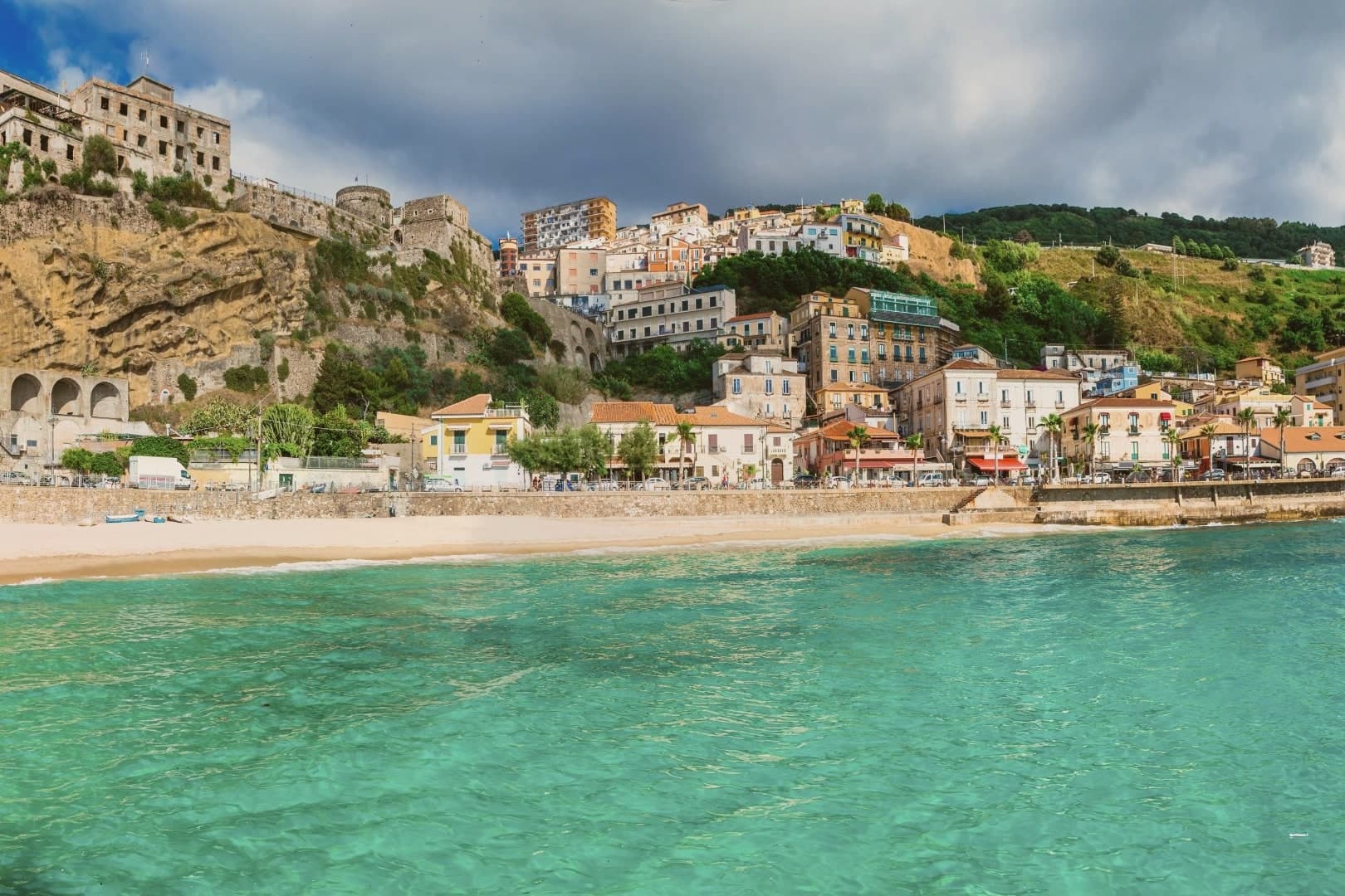
Parghelia sits on a low Tyrrhenian cliff at about 70 meters, on the stretch of coast tourism boards call the Costa degli Dei, four kilometers north of Tropea and fifteen west of Vibo Valentia. The commune is small (under 1,300 residents) and easy to overlook from the highway, which is part of why it has kept a residential pulse that Tropea has largely traded for tourism.
The beaches sit below the village, reached on foot through cuts in the sandstone: Michelino, with its dark cliffs, and the smaller coves toward Zambrone. The frazione of Fitili holds the older houses inland.
Bandiera Blu status has tracked the water quality for several seasons, and the coastal panorama opens north to the Gulf of Sant'Eufemia and south to the Capo Vaticano promontory. Most visitors who stay here do so to use Tropea without paying Tropea's prices.
The beach here holds the national bathing award, which a comune has to win back every year on water quality, beach management and safety.
What to see in Parghelia
- Spiaggia di Michelino. Curved beach below the village reached by stairs through the cliff, with dark sandstone walls and Bandiera Blu water.
- Centro storico. Compact village core on the headland, with the parish church of the Annunziata at its centre.
- Fitili. Inland frazione of Parghelia with older stone houses and the small church of San Nicola di Bari.
How to get to Parghelia
There is a railway station in the town, so you can arrive without a car and never need one while you are here. Reggio Calabria is roughly 96 minutes away by road.
Our tip
May through September is when Parghelia functions as a coastal village. Water is swimmable from late May, beach clubs run from June, and the parking constraints that plague Tropea are easier here. July and August are hot and busy, but the cliff-foot beaches stay calmer than the Tropea sand. Sagra del Pesce falls in August.
Roseto Capo Spulico
Why visit Roseto Capo Spulico
Roseto Capo Spulico sits at the northern edge of Calabria's Ionian coast, the last commune before the Basilicata border, with the Pollino massif rising behind it. The village began as a Magna Graecia satellite of Sybaris, its name tied to the roses once cultivated to fill the mattresses of the Sybarite elite.
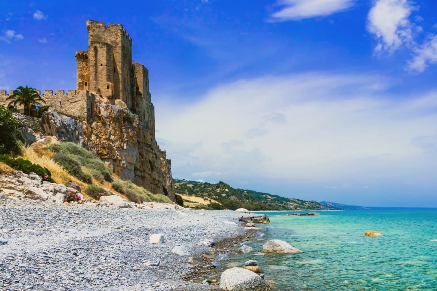
The castle above the water was requisitioned from the Templars in 1229 after their conduct during the Sixth Crusade, an episode that also carries a Shroud legend. The old town sits on the ridge above the marina, its stone houses and lanes looking down over the castle rock and the sea beyond it, while the beach runs along the shore directly below.
Inland, vineyards climb toward the Pollino slopes, and the commune holds recognition as a Borgo Autentico d'Italia and a Spiga Verde. The village reads as a settlement built in layers, from Sybarite outpost to fortress town to a place whose seafront, hilltop and inland farmland still sit visibly stacked, one above the other, along the same short stretch of coast.
The beach here holds the national bathing award, which a comune has to win back every year on water quality, beach management and safety.
What to see in Roseto Capo Spulico
- Castello Federiciano di Roseto Capo Spulico. Trapezoidal fortress with three towers, one taller and crenellated, standing directly on the sea. Built under Robert Guiscard and rebuilt by Frederick II after he took it from the Templars.
- Spiaggia del Castello. Pebbled Bandiera Blu beach directly below the castle rock, with clear water and small coves along the Costa degli Achei.
- Chiesa di Santa Maria delle Grazie. Sixteenth-century mother church in the centro storico, rebuilt after earthquake damage and dedicated to the patron of the village.
How to get to Roseto Capo Spulico
There is a railway station in the town, so you can arrive without a car and never need one while you are here. Taranto is roughly 93 minutes away by road.
Our tip
May through September are the months the Ionian beach is open and the castle promontory fills with day-trippers from Sibari and Basilicata. July and August push past thirty-five degrees and the marina rentals fully book; the centro storico on the ridge above stays quieter and cooler. April and October are dry and mild, the right time to walk the castle path and the Pollino foothills inland without sweat.
San Nicola Arcella
Why visit San Nicola Arcella
San Nicola Arcella sits at 110 meters on a cliff above the Tyrrhenian Sea in the northern Riviera dei Cedri, between Scalea and Praia a Mare. The settlement traces back to the Greek colony of Lao and its Roman successor Lavinium on the same stretch of coast.
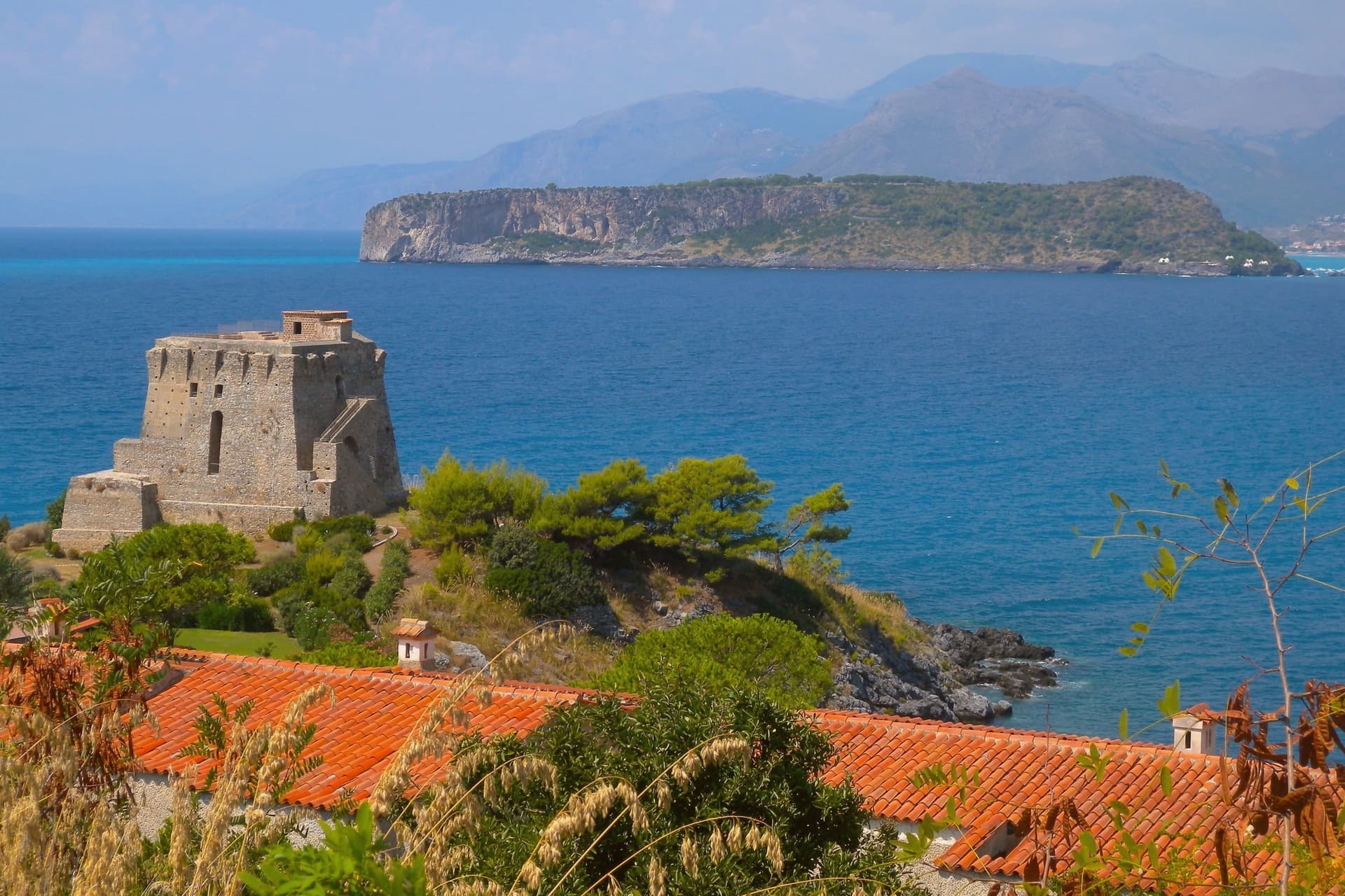
The hilltop relocation followed the Saracen raids of the early Middle Ages, when villagers moved uphill behind a watch tower, and the Arcella part of the name comes from the rock the village sits on. Prince Pietro Lanza Branciforte, who married the last heir of the Spinelli di Scalea family in the nineteenth century, expanded the fishing economy and built out the urban core, which became an autonomous commune in 1811.
That core still sits on the rock the raids drove people to, while the watchtower built for the same defense on the southern headland later found a second use as a writer's study. The village today is the sum of that retreat uphill and that later reuse: a defensive settlement that outlasted the danger it was built for and let the coast below it, arch, cove and all, become the draw instead.
The beach here holds the national bathing award, which a comune has to win back every year on water quality, beach management and safety.
What to see in San Nicola Arcella
- Spiaggia dell'Arco Magno. Inner cove reached only on foot or by boat, framed by a stone arch carved into the headland by the sea.
- Torre Crawford. Sixteenth-century anti-piracy watchtower on the southern headland, used as a study by American novelist Francis Marion Crawford in the 1890s.
- Centro storico. Hilltop core perched on the rock, rebuilt under the Lanza Branciforte princes in the nineteenth century around the parish church and the old casale.
How to get to San Nicola Arcella
Salerno is roughly 120 minutes away by road.
Our tip
May through September runs the whole village. Boats start the Arco Magno shuttle in late May, the Bandiera Blu beaches fill from mid-June, and July and August bring the heaviest crowds onto a small headland. Heat sits in the high twenties on the cliff; midday on the inner beach is reflected off the rock walls and harder than the open coast.
Fiumefreddo Bruzio
Why visit Fiumefreddo Bruzio
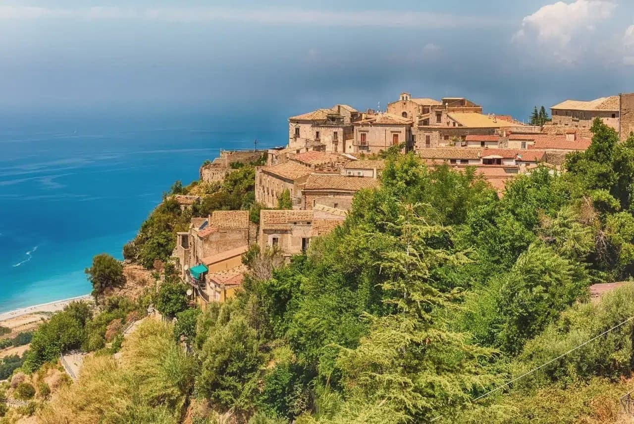
Fiumefreddo Bruzio sits at 220 metres on a hill above the Tyrrhenian, in the southern part of Cosenza province. The territory runs from sea level on the lungomare up to the peak behind the town, so the walk from shore to centro storico to mountain flank covers the whole of the place in one climb.
The castle occupies the high point of the settlement, sieged and nearly destroyed by French troops in 1806-1807 before recovering the Renaissance portal added centuries earlier. The mother church, San Michele Arcangelo, anchors the religious life of the centro storico separately from the castle, holding paintings by Solimena and Pascaletti since 1540.
What ties the upper town together now is the later layer left by the painter, who worked here each summer from the 1970s and scattered murals and sculptures through the lanes, the church dome, and the castle room he frescoed at 81. The result is a hill town where a medieval defensive core, a sixteenth-century church, and a twentieth-century painter's late work all occupy the same small radius of stone streets, with the mountain behind and the sea below holding the whole arrangement in place.
What to see in Fiumefreddo Bruzio
- Castello della Valle. Castle with a sixteenth-century Renaissance portal. Inside, the Stanza dei Desideri carries Salvatore Fiume's frescoes.
- Chiesa Matrice di San Michele Arcangelo. Mother church built in 1540 holding paintings by Francesco Solimena and Giuseppe Pascaletti, the main religious building of the town.
- Chiesa di San Rocco. Small church whose dome carries a Fiume painting, one point in his wider intervention across the centro storico.
How to get to Fiumefreddo Bruzio
Reggio Calabria is roughly 135 minutes away by road.
Our tip
May through September is the working season: warm Tyrrhenian sea below, mild hilltop temperatures at 220 metres, and the castle open for visits. June stays in the high twenties on the hill; July and August can push past thirty-five, and the lungomare three kilometres downhill fills with summer residents from Cosenza. September is the better month for the castle frescoes and the centro storico walks, with the air clearer toward Monte Cocuzzo. Mercato Settimanale Di Fiumefreddo Bruzio falls in September.
Rocca Imperiale
Why visit Rocca Imperiale
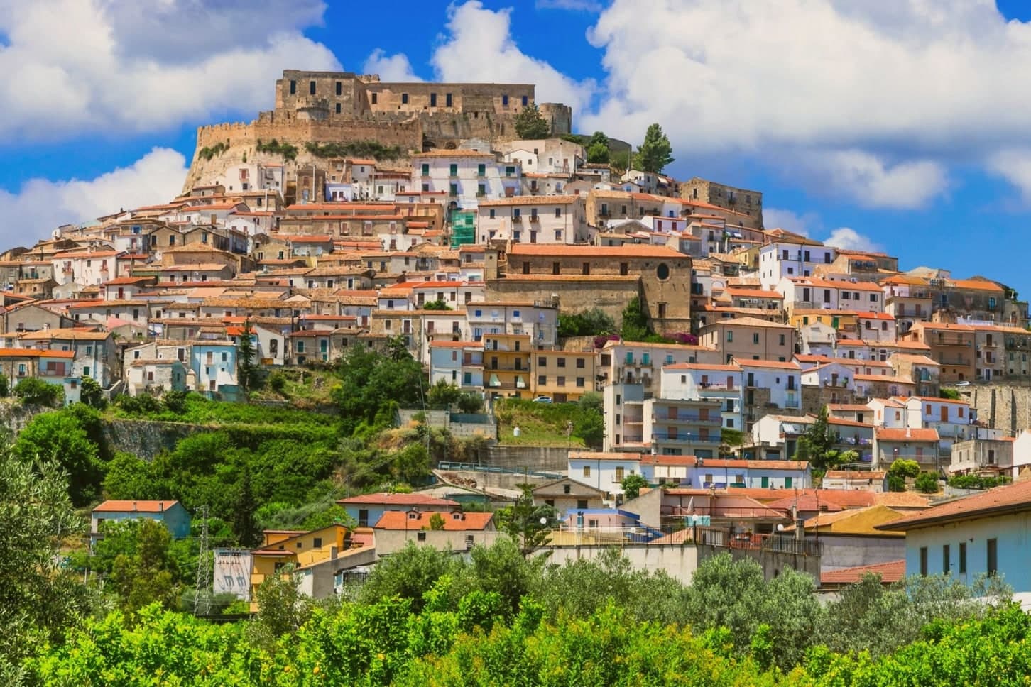
Rocca Imperiale is the northernmost commune of Calabria, pressed against the Basilicata border on the Ionian coast. The hilltop borgo sits a kilometre inland from the long sandy Marina, the two connected by the slope the town has always used to move between fortress and shore.
The castle stands on a defensible hill chosen to command the coastal route between Taranto and Reggio Calabria, and the borgo grew downhill from it in tight medieval grids of whitewashed houses and narrow vicoli, with the Chiesa Madre dell'Assunta, a 15th-century church with a Madonna by Pietro Bernini, father of Gian Lorenzo, anchoring the central piazza. Inland and upland frame the town on the other side: the Pollino park lies 30 km west and the Sila highlands further south, making Rocca a base for both while the coastal frazione below handles the beach trade.
The food is north-Calabrian-meets-Lucanian: peperoni cruschi, pasta with lardo and chilli, pesce azzurro from the Ionian, and the lemon grown only in the surrounding belt, used in liqueurs and the local pasta al limone. The Festa del Limone in early August is the year's main event.
The town works because its geography does the sorting: fortress and church hold the hill, the lemon groves hold the middle slope, and the marina holds the shore, each part visible from the others across the same short drop to the sea.
The beach here holds the national bathing award, which a comune has to win back every year on water quality, beach management and safety. It is also rated for accessibility, which most of this coast is not.
What to see in Rocca Imperiale
- Castello Federiciano (1225). Frederick II Hohenstaufen's square fortress with four corner towers (two cylindrical) commanding the Ionian coastal route. Open as a cultural centre.
- Centro storico (Borghi più belli). Whitewashed houses in tight medieval vicoli cascading downhill from the castle. The Chiesa Madre dell'Assunta has a Pietro Bernini Madonna.
- Rocca Imperiale Marina (Bandiera Blu). Long sandy Ionian beach 1 km below the borgo, holding the Bandiera Blu every recent year for water clarity and beach management.
How to get to Rocca Imperiale
There is a railway station in the town, so you can arrive without a car and never need one while you are here. Taranto is roughly 81 minutes away by road.
Our tip
Rocca Imperiale is best May–June and September–October — the borgo cool in the morning, the Marina swimmable, the lemon orchards in flower or harvest. July–August fills the Marina with Italian families and the Festa del Limone (early August) is the biggest event. The borgo stays atmospheric in winter but most amenities at the Marina close November–March.
Scilla
Why visit Scilla
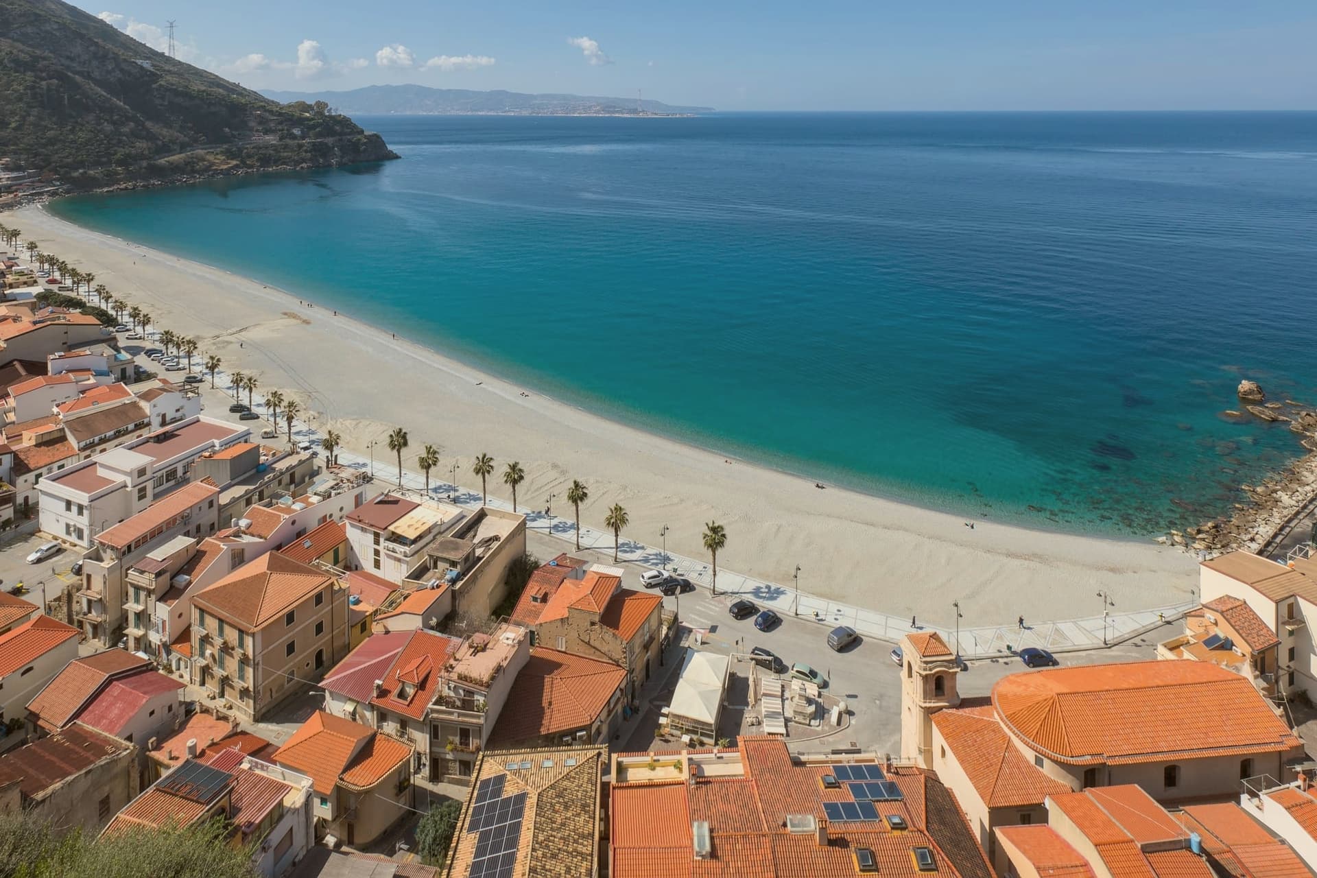
Scilla sits on the Scilleo promontory at the northern end of the Strait of Messina, on the Tyrrhenian Costa Viola in the metropolitan city of Reggio Calabria. The town spreads around the Castello Ruffo, the fortress whose origins reach back to the fifth century and which the Ruffo family rebuilt to its present form in the fifteenth.
Homer set the episode of Scylla and Charybdis here in the Odyssey; local tradition places the monster on the rock the castle now occupies. Below the cliff to the north, the fishing district of Chianalea, member of I Borghi più belli d'Italia, runs as a single line of houses with their walls plunging straight into the sea.
The swordfish boats with their distinctive tall watchtowers and long bow walkways still work the Strait between May and September, an artisanal hunt that has continued in these waters for centuries. Sicily is visible across the water on most days.
What to see in Scilla
- Castello Ruffo. Fifth-century origin cliff fortress reshaped by the Ruffo family in the fifteenth century, standing on the rock Homer identified with Scylla in the Odyssey.
- Chianalea. Fishing district north of the castle, a single line of houses whose walls plunge straight into the sea, member of I Borghi più belli d'Italia.
- Marina Grande. Curving beach south of the promontory, the principal swimming shore of the town with the castle as backdrop.
How to get to Scilla
Reggio Calabria is roughly 55 minutes away by road.
Our tip
May through September is the season. The swordfish boats work the Strait, the Marina Grande fills, and Chianalea's tight lane of houses turns into one continuous fish-restaurant evening. July and August are busy; the Costa Viola is one of southern Calabria's best-known stretches and rooms book months ahead.
More from Anywhere Italy
- The best hidden beach towns in Calabria
 The best small towns you can reach by train in Calabria
 The prettiest villages in the province of Cosenza
- The 8 best coastal towns that eat well in Calabria
- The best hidden beach towns you can reach by train in the province of Cosenza
- The best hidden towns you can reach by train in the province of Cosenza