
The best coastal towns within two hours of Padua

This is not a coast of cliffs. Between the mouths of the Po and the Isonzo the land dissolves gradually into reed beds, salt pans and shallow lagoons crossed by wooden fishing huts on stilts. The towns here are built of plastered brick and canal stone, painted in ochre and faded pink, with boats tied up at the end of the street rather than in a marina. Autumn brings eel, and spring brings clams, cuttlefish and the thin white asparagus that comes down from the sandy inland fields. Seafood is grilled plainly or stewed with vinegar and onion, and it is eaten with Friulian white wine or the flat, dry whites of the delta.
Most people heading east from Padua go to Venice, and the lagoon they see is the one crossed by vaporetto between San Marco and Murano. It is a magnificent thing to look at and an exhausting thing to move through, particularly between May and September when the day-trip traffic peaks and the queues at the basilica run along the arcades. The Lido and Jesolo absorb the overflow with their beach clubs and rows of loungers. All of it is worth seeing once, and all of it is busy.
The lagoon does not stop at Venice. It continues north past Aquileia's Roman quays and up to the Friulian fishing channels, and it runs south through the delta to the eel canals of the Comacchio marshes. The same shallow water, the same seafood, the same low brick, with far fewer people in the streets and working boats still going out. These are the towns along that coast, all of them within about two hours of Padua by road or rail.
Of the 80 communes we have mapped in a 120-minute drive of Padua, 6 qualify as coastal towns: each is on the sea. The smallest, Marano Lagunare, has 1,713 residents.
If you are still choosing, we have also written The best coastal towns within two hours of Venice and The best coastal towns within two hours of Udine.
Marano Lagunare
Why visit Marano Lagunare
Marano Lagunare sits on a single fingertip of land at the mouth of the Stella river, surrounded by the Laguna di Marano and Grado: the largest lagoon in Friuli-Venezia Giulia. The town was a Roman port, Maranum, mentioned by Pliny, then a fishing town under the Patriarchate of Aquileia, then a fortified Venetian outpost from 1420 until the fall of the Republic in 1797.
Each layer left its mark on the same small footprint: the Roman-era estuary settlement, the Aquileian fishing economy that still runs the harbour, and the Venetian grid of houses and watchtower around the piazza. The fleet and the lagoon are the same fact seen from two sides.
The moeche harvest, the schie shrimp, and the daily catch move directly from boat to osteria, and the dialect spoken in the streets is a pocket of Venetian speech that outlasted the Republic itself, holding on in a region that speaks Friulian. The town's whole history reads as a single settlement repeatedly absorbed by larger powers, Roman, Aquileian, Venetian, without ever losing the lagoon that defines its geography and its economy alike.
What to see in Marano Lagunare
- Porto e centro storico. Pastel-coloured fishermen's houses in a tight grid around a single piazza, with the watchtower anchoring the harbour where the fleet still ties up.
- Laguna di Marano. Moeche soft-shell crab harvest runs spring and autumn, alongside daily fishing. Small-boat tours reach the casoni, traditional thatched fishermen's huts on the lagoon islands.
- Riserva Naturale Foci dello Stella. Natura 2000 wetland at the Stella river estuary, reachable by short boat hop from the harbour. Reedbeds, birding hides, herons and migratory waterfowl.
How to get to Marano Lagunare
Udine is roughly 44 minutes away by road.
Our tip
April through October is the prime season — calm lagoon, working fleet daily, and the osterie at full menu. May and September are the moeche soft-shell-crab seasons; the local boats land them at dawn and the osterie serve them within hours. June bears the highest summer light over the lagoon; July-August are hot and busy with regional tourism but the lagoon stays workable. Fasolari in Festa falls in August.
Aquileia
Why visit Aquileia
Aquileia sits at five meters above sea level on the Friuli plain, ten kilometers inland from the Adriatic at the head of the Grado lagoon. Rome founded it as a military colony in 181 BC.
By the second century AD it held close to 100,000 people, was the capital of Augustus's Regio X, and ranked among the nine great cities of the empire. Attila's Huns sacked it in 452, the population scattered to the lagoon islands, and the surface town never recovered.
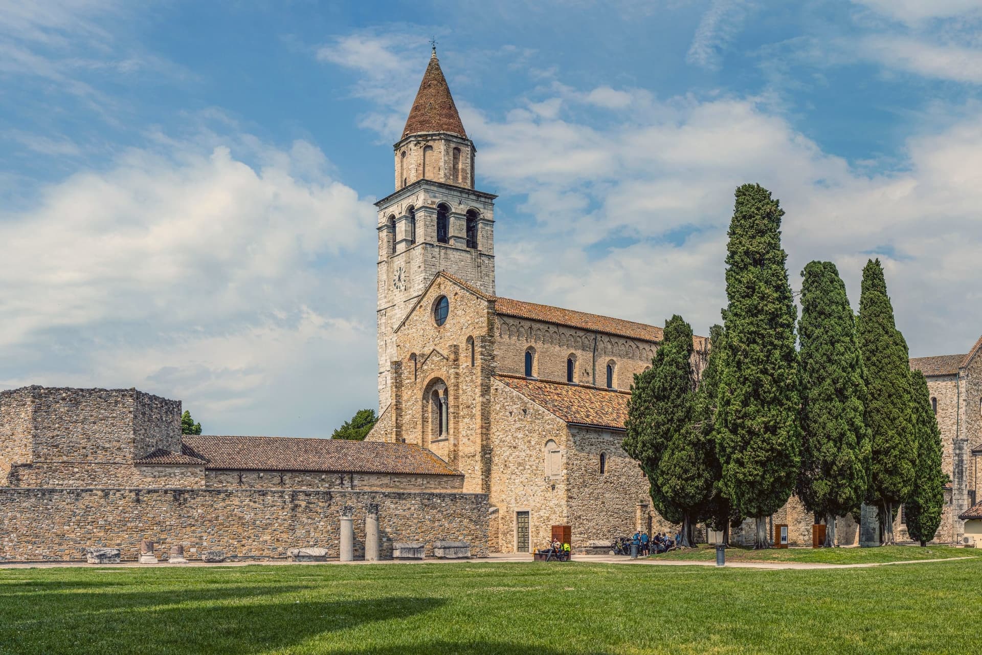
The Roman city below is largely unexcavated, which makes Aquileia, in UNESCO's words, the most complete example of an Early Roman city in the Mediterranean. Above it, Patriarch Poppo rebuilt the basilica in 1031 over a fourth-century church.
Its floor is the largest paleochristian mosaic in the Western world, 760 square meters of fish, birds, jonah and the whale, uncovered by archaeologists in 1909. The 73-meter campanile uses stone quarried from the Roman amphitheater.
The Patriarchate of Aquileia survived until 1751.
What to see in Aquileia
- Basilica di Santa Maria Assunta. Patriarch Poppo's eleventh-century basilica over a fourth-century church, with a 760-square-meter paleochristian mosaic floor uncovered in 1909.
- Campanile di Poppo. Free-standing 73-meter bell tower built in the eleventh century with stone quarried from the Roman amphitheater, raised again in the fourteenth.
- Foro Romano. Excavated section of the Roman forum along the Via Sacra, with the bases of columns and reused capitals from the second century AD.
How to get to Aquileia
There is a railway station in the town, so you can arrive without a car and never need one while you are here. Udine is roughly 43 minutes away by road.
Our tip
May through September is the working season for Aquileia. The basilica is open daily, the archaeological park stays light until late, and the lagoon at Grado five kilometers south is swimmable. July and August are hot and humid on the plain, often pushing above thirty-two degrees, and the mosaic floor is the coolest room in town. Festa dell'Unità falls in July.
Rosolina
Why visit Rosolina
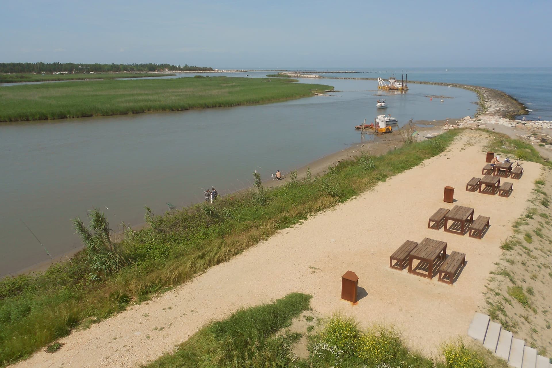
Rosolina sits at three meters above sea level, forty kilometers south of Venice, between the Adige to the north and the Po di Levante to the south, at the northern edge of the Po Delta. The commune is recent: it was drained and made habitable through twentieth-century land reclamation that built channels, raised banks and pulled the land out of the lagoon.
The territory divides into three distinct parts. The frazione of Rosolina Mare holds the mainland coast, backed by the replanted pine forest.
The Isola di Albarella sits offshore as a private, gated development, separate in ownership and access from the rest of the commune. Inland, the reclaimed land carries the traces of the drainage works themselves, documented at the Ca' Vendramin pump station near the commune border.
The land here is not old ground reshaped but new ground made, and the three parts of the commune, the resort island, the public beach and the drained interior, are three different answers to the same reclamation.
The beach here holds the national bathing award, which a comune has to win back every year on water quality, beach management and safety.
What to see in Rosolina
- Rosolina Mare. The beach carries the Bandiera Blu, earned through repeated cycles. The pines behind it have matured into dense woodland since the original planting.
- Parco regionale veneto del Delta del Po. Regional park covering nine communes from the Adige to the Po di Goro, with lagoons, valleys and bird colonies.
- Giardino Botanico Litoraneo. Coastal botanical garden on the dune system, classified as a Site of European Significance for its dune and lagoon flora.
How to get to Rosolina
Venezia is roughly 79 minutes away by road.
Our tip
May through September is the working season. The beach fills with Italian and Central European families through July and August, peak temperatures push past thirty degrees, and the pine forest gives the only shade. Rosolina Mare empties dramatically after the third week of August.
Grado
Why visit Grado
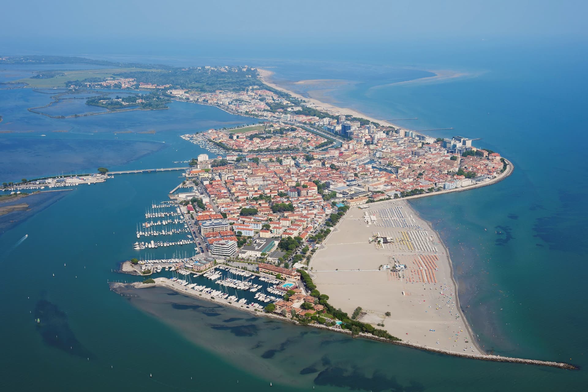
Grado is an island town in the Marano-Grado Lagoon, between Venice and Trieste, on a 90-square-kilometer mosaic of shallow water, sandbanks, and reedbeds. When the Lombards took Aquileia in 568, the metropolitan fled here; the Aquileian see was transferred to Grado in 579 and the town became known as New Aquileia.
Bishop Elia consecrated the Basilica of Sant'Eufemia on November 3, 579, on the patriarchal square. The patriarchate moved to Venice in 1105 and was formally suppressed in 1451, but Grado kept the basilica, the sixth-century baptistery, and the lapidarium.
The town became Italian seaside in the Habsburg sense in the nineteenth century, when Empress Sissi's circle gave it the imperial bathing certification; the long sandy beaches and lagoon climate did the rest. Today it carries the Bandiera Blu and is the only Italian Adriatic resort that opens directly south, with full-day sun.
The casoni, thatched fishermen's huts on the lagoon islets, are still in use.
The beach here holds the national bathing award, which a comune has to win back every year on water quality, beach management and safety.
What to see in Grado
- Basilica di Sant'Eufemia. Sixth-century basilica consecrated in 579 by Patriarch Elia, with original mosaic floor, lapidarium, and the suppressed patriarchal cathedra of Grado.
- Battistero di Sant'Eufemia. Hexagonal sixth-century baptistery next to the basilica, with octagonal immersion font and the oldest preserved liturgical architecture in the lagoon.
- Basilica di Santa Maria delle Grazie. Fifth- to sixth-century three-nave basilica on the patriarchal square, with original mosaic flooring and remains of the earlier early-Christian structure.
How to get to Grado
Udine is roughly 46 minutes away by road.
Our tip
May through September is the season the town was rebuilt for. Beach umbrellas line the southern shore, lagoon boats run scheduled trips out to the casoni and the Valle Cavanata, restaurant tables spread out along the riva. July and August fill with Austrian, German, and Italian families on full bathing weeks; book ahead and expect price surcharges.
Comacchio
Why visit Comacchio
Comacchio sits at sea level fifty kilometers east of Ferrara and forty south of the Adriatic delta proper. The town passed through Etruscan hands, then Byzantine rule under the Exarchate of Ravenna, then the Duchy of Ferrara, then Papal government until unification, a succession that left the centro storico layered rather than uniform.
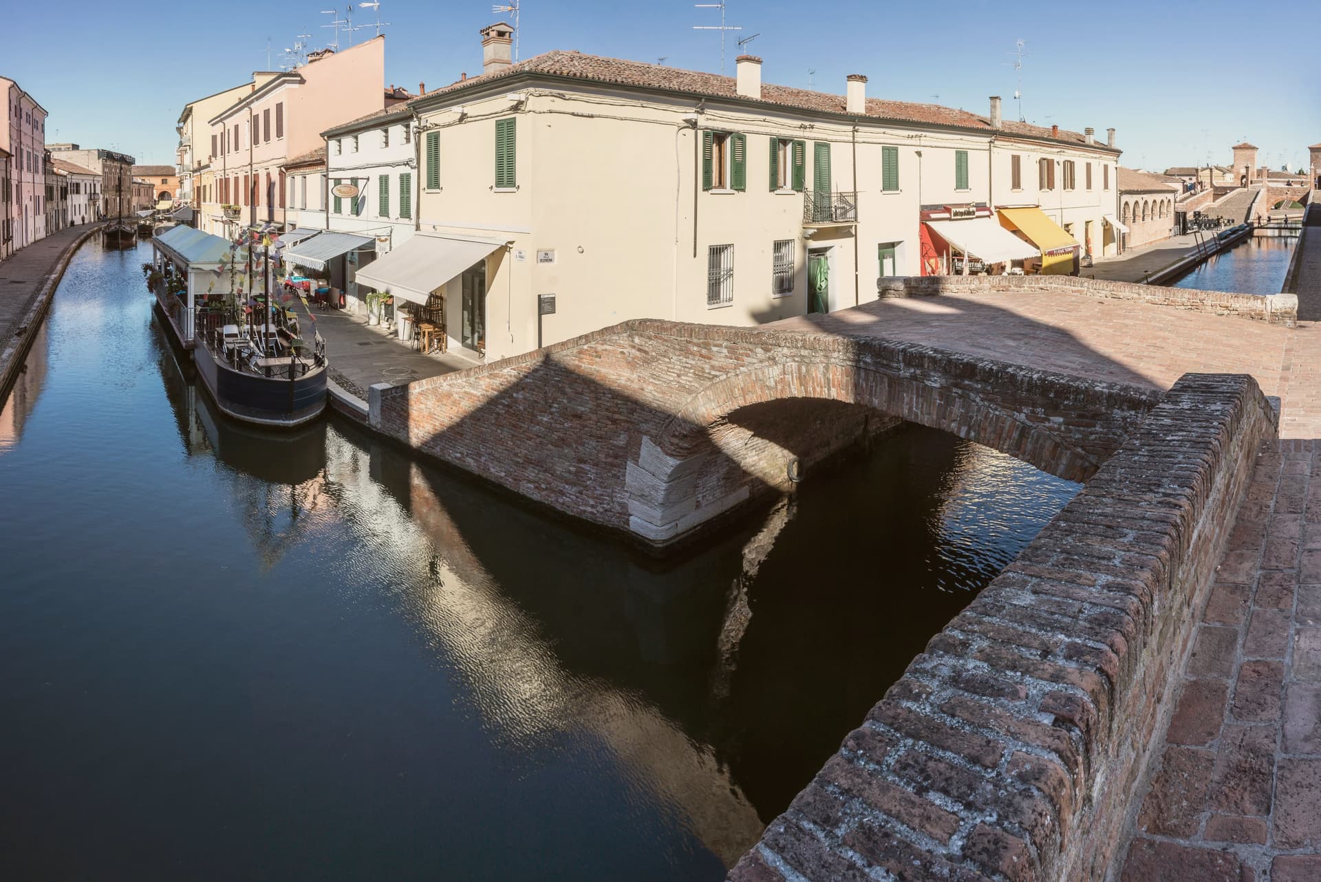
The lagoons that surround it formed from tenth-century subsidence and later silting, and now run as a protected area inside the UNESCO inscription that covers the historic Ferrara plain, linking the town to the wider delta rather than setting it apart. The old town itself is water-built: thirteen islets tied together by bridges, canals threading between the Loggia del Grano and the Loggiato dei Cappuccini, with the bridge acting as the hinge where the inland waterways meet the canal running out toward the sea.
What the layers of rule left behind in stone, the lagoon and the tides have kept in motion around it: a town whose center is inseparable from the water that surrounds it, built up in pieces by whoever governed it at the time.
The beach here holds the national bathing award, which a comune has to win back every year on water quality, beach management and safety.
What to see in Comacchio
- Ponte dei Trepponti. Built around 1638 by Luca Danese of Ravenna, the bridge is the meeting point of three internal canals with the canal Pallotta and the symbol most visible from the water.
- Valli di Comacchio. The lagoon opens flat to the horizon at the edge of the Po Delta, its surface broken by fishing stations and the pink of the resident flamingo colonies.
- Museo Delta Antico. Archaeological museum opened in 2017 inside the eighteenth-century Ospedale degli Infermi, with finds from the Etruscan necropolis of Spina.
How to get to Comacchio
Ravenna is roughly 45 minutes away by road.
Our tip
May through September is the working season for Comacchio. Late May and June are best, when the lagoons hold migrating birds and the heat has not yet pushed visitor numbers into the August peak. The Valli boat tours run from spring to autumn, with flamingos visible all year round on the brackish edges. Festa di San Cassiano falls in August.
Chioggia
Why visit Chioggia
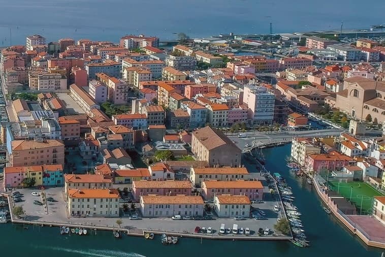
Chioggia sits at 2 meters on a small island at the southern entrance to the Venetian Lagoon, twenty-five kilometers south of Venice and connected to the mainland and to its frazione Sottomarina by causeways. The Romans knew it as Clodia.
By the eleventh and twelfth centuries it had grown into a salt-producing port and became a free commune in 1110. The naval war that carries the town's name ran through 1378-81 and ended Genoese rivalry with Venice, leaving Chioggia under the Serenissima for the next four centuries.
The defeat reduced the town to fishing, salt and limited Adriatic trade. The fleet never left.
The street plan is a herringbone of calli running off the town's single straight spine, with three canals threading between them and the bridges that gave the town its Little Venice nickname. Inland lies the historic island itself; across the causeway sits Sottomarina, the beach frazione facing the open Adriatic where the lagoon town has none.
What Chioggia lost at sea it kept at the dock: a working port still built around the same trade that outlasted the war which was supposed to end it.
The beach here holds the national bathing award, which a comune has to win back every year on water quality, beach management and safety.
What to see in Chioggia
- Cattedrale di Santa Maria Assunta. Cathedral founded in the eleventh century, raised to episcopal seat in 1110, rebuilt from 1623 to designs by Baldassare Longhena.
- Canale Vena. Main canal of the centro storico, lined with fishing boats and crossed by nine bridges including the seventeenth-century Ponte Vigo.
- Mercato del Pesce. Wholesale fish market on the canal, open before dawn six days a week, the operating center of the Adriatic fleet.
How to get to Chioggia
There is a railway station in the town, so you can arrive without a car and never need one while you are here. Venezia is roughly 46 minutes away by road.
Our tip
May through September is the working season. June and early July bring warm Adriatic water and the long Sottomarina beach to capacity on weekends; mid-August fills it past comfort. The Sagra del Pesce on the third weekend of July puts the whole fleet on display along Canale Vena.
More from Anywhere Italy
- The best coastal towns within two hours of Venice
- The best coastal towns within two hours of Udine
 The best hot-spring towns within two hours of Padua
 The best coastal towns within two hours of Bologna
 The best towns that cure their own meat within two hours of Padua
- The best towns that eat well within 75 minutes of Trieste