
The best towns you can reach by train in the province of Salerno
The province of Salerno runs from ceramic-tiled roofs above the Gulf of Salerno down through olive terraces and buffalo pasture to the long sandy beaches of the Cilento. It is a coast built of tufa and limestone, with fig trees in the walls and boats hauled up on shingle below the old towers. This is mozzarella di bufala country, and further south the anchovies of the Cilento, salted in terracotta, and white figs dried in September. The trains that follow the shoreline pass close enough to the water that the sea fills the window for long stretches between tunnels.
Most people arrive here for the Amalfi Coast, and most of them arrive by coach or by ferry into Amalfi and Positano, where the road narrows to a single lane of stalled traffic through high summer. The scenery earns the attention, but the famous stretch has no railway at all, which means buses, boats and queues at the bus stop. Ravello fills its gardens by mid-morning. It is a coast designed for walking that has become a coast spent waiting.
The same limestone, the same lemon terraces and the same anchovies continue south past the resorts, and the railway continues with them, running down the Cilento and inland towards the Vallo di Diano. Fewer people get off at these stations. The towns below sit on that line or within reach of it without a car, which for anyone flying into Naples is the simplest way to see this province at all.
Of the 27 communes we have mapped in the province of Salerno, 7 qualify as towns you can reach by train: we have confirmed each is reachable without a car. The smallest, Auletta, has 2,124 residents.
Two more lists worth reading alongside this one: The best coastal towns inside a national park in Campania and The best beach towns in the province of Salerno.
Auletta
Why visit Auletta
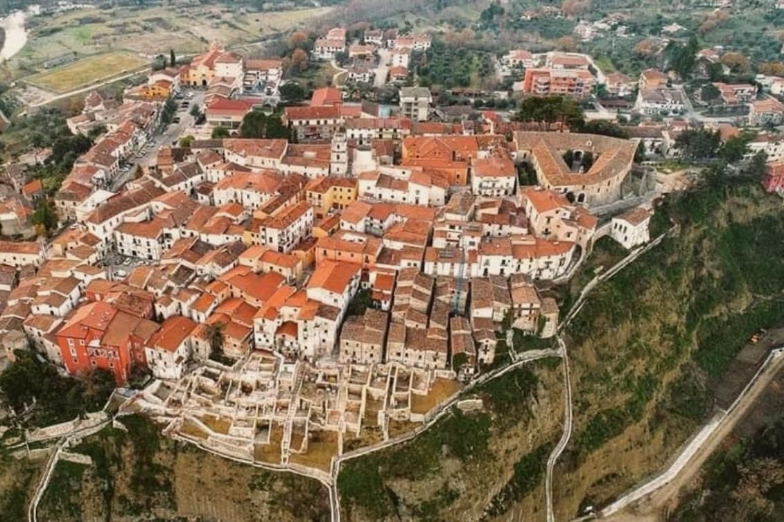
Auletta sits at 280 meters on a hill on the right bank of the Tanagro river, at the northern edge of the Vallo di Diano, inside the Cilento, Vallo di Diano and Alburni National Park. The town was fortified by the year 1000 and is mentioned as Olibola in 1095, possibly from olea, Latin for oil.
The medieval core is reached through three gates, Porta Castello, Porta del Fiume and Porta Rivellino. The Castello Marchesale, twelfth century in origin, took its current shape in the fifteenth, when defensive systems were added; it is privately owned by the Maioli Castriota Scanderbech family.
The 1857 Great Neapolitan earthquake destroyed much of the town and was documented by the Irish seismologist Robert Mallet, in the first systematic post-earthquake survey ever attempted. In 1861, immediately after Unification, locals rose against the Piedmontese army and 45 were killed in what is remembered as the Auletta Massacre.
The town is now a Città delle Grotte for its proximity to the Pertosa-Auletta caves.
We confirmed you can reach this one by train.
What to see in Auletta
- Castello Marchesale. Twelfth-century fortress in the highest part of the centro storico, reshaped in the fifteenth century with defensive walls and now privately held.
- Chiesa di San Nicola di Mira. Parish church inside the medieval walls, holds a relic of San Donato di Ripacandida, the town's patron saint.
- Borgo dei Mestieri. Restored part of the centro storico turned into a living museum of traditional Cilento crafts, with workshops on stone, iron and clay.
How to get to Auletta
There is a railway station in the town, so you can arrive without a car and never need one while you are here. Salerno is roughly 49 minutes away by road.
Our tip
April through October is the open season in the Tanagro valley: clear days, mild nights and the National Park trails dry enough to walk. July and August push past thirty-three degrees in the valley; the centro storico on the hill catches a slight breeze. April, May and early June are the right weeks for the Alburni hikes and the Pertosa-Auletta caves, which run at fifty degrees year-round and feel cold off a hot afternoon.
Pisciotta
Why visit Pisciotta
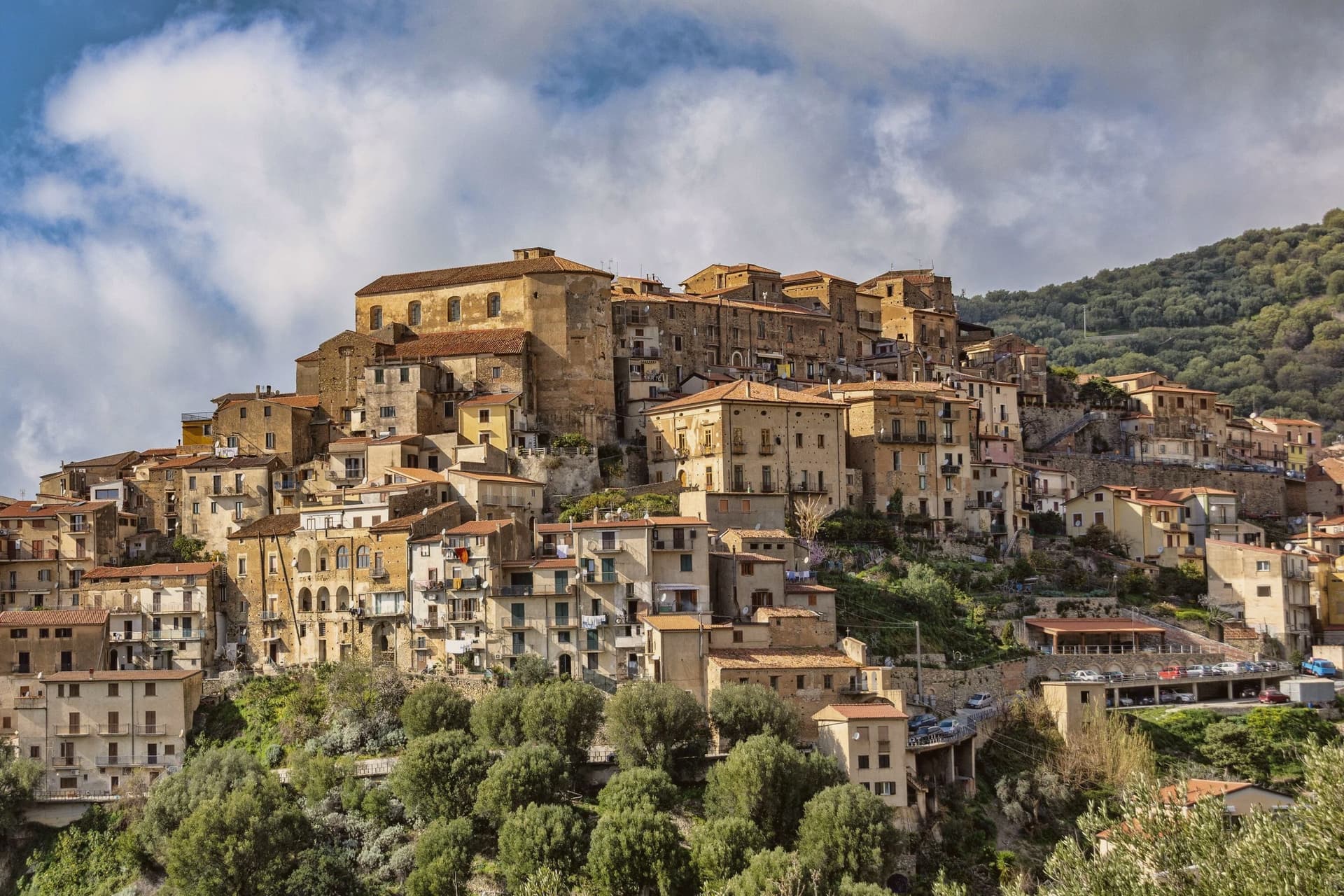
The hill the town occupies rises between Ascea and Palinuro, part of the strictest zone of the Cilento and Vallo di Diano National Park, and the ridge gives the stone houses of the centro storico a clear line of sight to Capo Palinuro twelve kilometers south. The town's parts sit at different elevations doing different work: the historic core holds the ridge at 171 meters, the olive terraces cover the slopes below it, and Marina di Pisciotta occupies the shore at the foot of the hill, where the fishing boats go out.
The menaica net worked by the Marina's fishermen is a technique once widespread around the Mediterranean and now reduced to a few coves, of which this is one. Carlo Pisacane's failed 1857 revolutionary expedition landed at Sapri and was crushed nearby; the Cilento coast keeps the memory in plaques and processions rather than in any structure at Pisciotta itself.
What holds the town together is elevation: everything of note here, the anchovies, the olives, the beach, the ridge, is defined by how far it sits above or below that 171-meter line.
We confirmed you can reach this one by train.
What to see in Pisciotta
- Centro storico di Pisciotta. Hilltop medieval core of stone houses on a ridge 171 meters above the sea, with a clear sightline to Capo Palinuro.
- Marina di Pisciotta. Fishing port at the foot of the hill, departure point for the last menaica anchovy boats on the coast, its beach holding the Blue Flag.
- Uliveti di Pisciottana. Terraces holding trees of considerable age, the source groves of the Cilento DOP extra-virgin oil.
How to get to Pisciotta
There is a railway station in the town, so you can arrive without a car and never need one while you are here. Salerno is roughly 138 minutes away by road.
Our tip
May through September is the open season on the Cilento coast: clear water, warm evenings and the menaica boats out at night. July and August push past thirty-five degrees and the Marina rentals book; the centro storico on the hill above stays a few degrees cooler in the breeze. April and October are dry and mild, the right time for the olive harvest road and Parco Nazionale walks without heat.
Padula
Why visit Padula
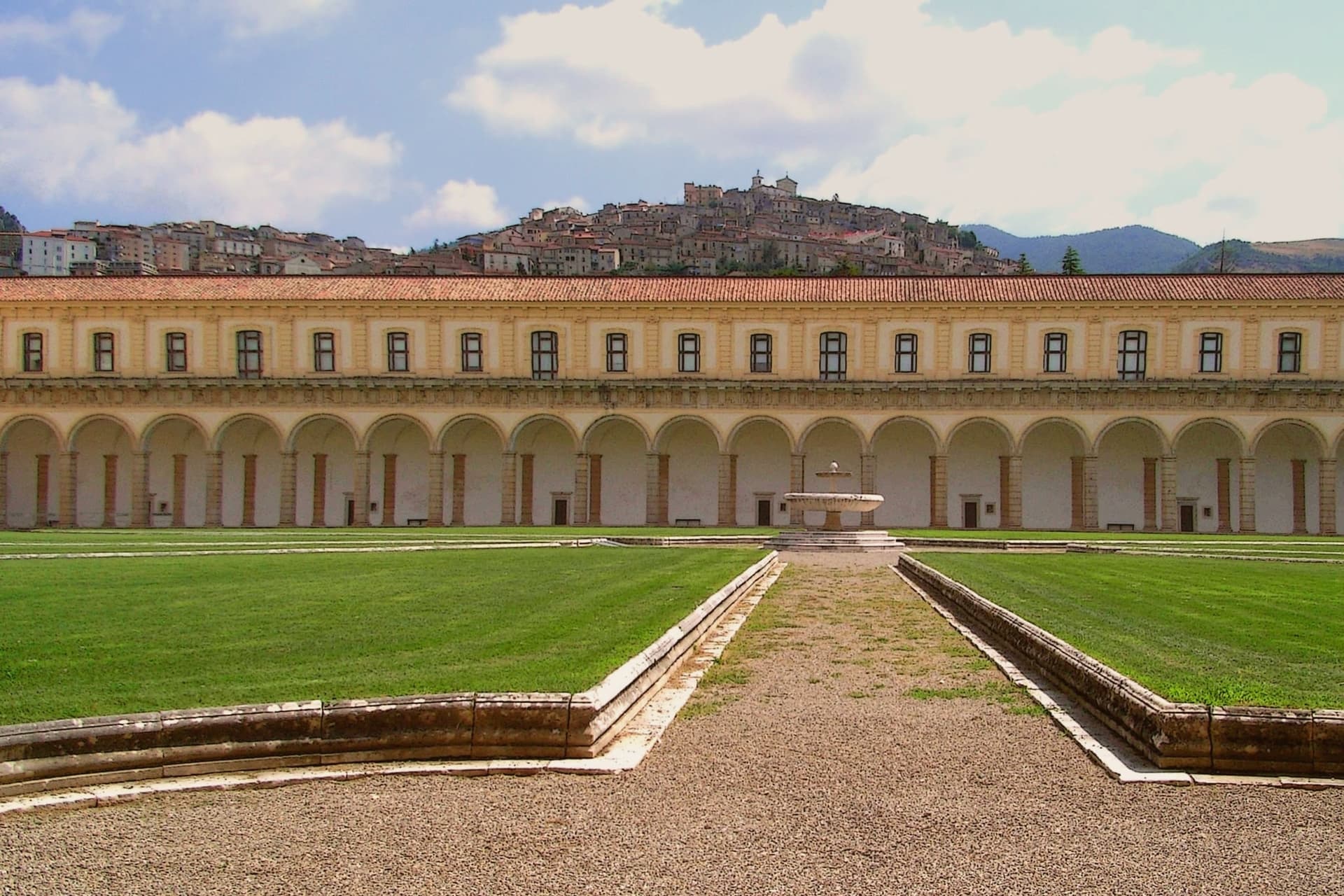
Padula sits on two hills above the Vallo di Diano, the long valley between the Cilento and the Lucanian Apennines. The monastery was founded on 27 April 1306 by Tommaso di Sanseverino, and UNESCO listed it in 1998 as part of the Cilento and Vallo di Diano serial site.
The medieval centro climbs the hill above it, stone houses and narrow lanes rising to the church of San Michele Arcangelo at the summit, from where the valley opens out below. It was in these streets that the 1857 volunteers were captured and killed, an event the town still marks with its monument.
The commune is also Città del Pane, for the round wheat loaves baked in local wood ovens. Padula reads as a town built around a single enormous fact below it and a smaller, older settlement above, the two connected by a hillside that has seen both monastic ambition and a violent end to a political expedition.
We confirmed you can reach this one by train.
What to see in Padula
- Certosa di San Lorenzo. 320 rooms and 51,500 m² of floor above the Vallo di Diano, its plan said to recall the griddle on which the dedicatee saint was burned alive. Built and rebuilt over four centuries by Carthusians suppressed in 1866.
- Centro storico di Padula. Medieval hill town above the monastery, with stone houses, narrow lanes, and the church of San Michele Arcangelo at the top.
- Battaglia di Padula. Monument to the fight in which the volunteers were captured and killed by Bourbon troops and local farmers in the streets of the centro.
How to get to Padula
There is a railway station in the town, so you can arrive without a car and never need one while you are here. Salerno is roughly 73 minutes away by road.
Our tip
May through September is the strongest window. The Vallo di Diano at 699 meters keeps cool nights even in August, and the Certosa di San Lorenzo opens longer hours through summer. July and August can climb past thirty degrees on the valley floor but the hill above keeps a usable breeze.
Ascea
Why visit Ascea
Ascea sits on the southern Cilento coast, two settlements in one comune: Ascea Paese at 230 meters above olive groves, and Ascea Marina on the flat between the Alento river and the sea. The Greek colonists from Phocaea founded Hyele here around 538 BC after fleeing the Persians; the city became Elea in Greek and Velia in Roman times, and produced the Eleatic school of Parmenides and Zeno that founded Western metaphysics.
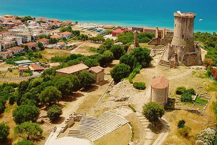
The archaeological park keeps the Porta Rosa, the oldest known round arch in Europe, an Ionian temple acropolis, Roman baths and the medieval Castelluccio Angioino built on the city's highest point. Modern Ascea is a Bandiera Blu beach commune of nine kilometres of sand inside the Cilento, Vallo di Diano and Alburni National Park, with the Spighe Verdi mark for agro-environmental quality.
We confirmed you can reach this one by train.
What to see in Ascea
- Parco Archeologico di Elea-Velia. Ruins of the Greek city founded around 538 BC by Phocaeans, home to Parmenides and the Eleatic school, with Porta Rosa, Ionic temple acropolis and Roman baths.
- Castelluccio Angioino. Medieval Angevin tower built on the highest point of ancient Velia, reusing Greek and Roman masonry, restored as the park's viewpoint.
- Marina di Ascea. Nine kilometres of fine sand between the Alento river mouth and Punta del Telegrafo, Bandiera Blu and Spighe Verdi within the Cilento national park.
How to get to Ascea
There is a railway station in the town, so you can arrive without a car and never need one while you are here. Salerno is roughly 110 minutes away by road.
Our tip
May through September is the open Cilento summer, with the Marina filling up from late June onward and the archaeological park staying open for evening visits in July and August. Mid-summer touches the high thirties and the beach absorbs most of the day; the paese on the hill stays a few degrees cooler. April and early October are dry and quiet, ideal for walking Velia without crowds or sun damage to the stone.
Vietri sul Mare
Why visit Vietri sul Mare
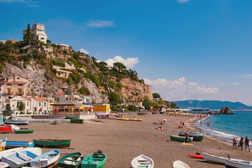
Vietri sul Mare sits at 80 meters at the eastern end of the Costiera Amalfitana, the most populous commune of the UNESCO-listed coastline, separated from the port of Salerno by a single harbour wall. The polychrome ceramics tradition is documented from the ninth century, with a generally agreed start around the fifteenth, and the industrial scale-up came in the 1920s and 1930s when a small group of German émigré artists settled in the workshops and brought the bestiary-and-floral pottery the town still produces.
The Chiesa di San Giovanni Battista, sixteenth century, has a green-and-yellow majolica dome that has become the town's signature image. Vietri is the only Amalfi Coast commune that holds Borghi più belli d'Italia and UNESCO together, and is a member of the Città della Ceramica network.
The marina at Marina di Vietri and the cliffside frazione of Raito and Albori sit below and above the centro on the same slope.
We confirmed you can reach this one by train.
What to see in Vietri sul Mare
- Chiesa di San Giovanni Battista. Sixteenth-century parish church with a green-and-yellow majolica dome and a bell tower of polychrome tiles, the most photographed image of the town.
- Museo Provinciale della Ceramica. Ceramic museum in Villa Guariglia at Raito, with Vietri pieces from the seventeenth century through the German-period 1920s and after.
- Albori. Cliffside frazione above the centro, also a Borgo più bello d'Italia, with stone houses, lanes, and views over the Gulf of Salerno.
How to get to Vietri sul Mare
There is a railway station in the town, so you can arrive without a car and never need one while you are here. Salerno is roughly 16 minutes away by road.
Our tip
May, June, September and early October are the strongest months. The water along the Marina di Vietri climbs past twenty degrees, the SS163 west to Cetara and Maiori runs without the gridlock of high summer, and the ceramic workshops keep their full hours. July and August are full: day-trippers arrive from Salerno on the local train and the Marina parking fills before mid-morning.
Agropoli
Why visit Agropoli
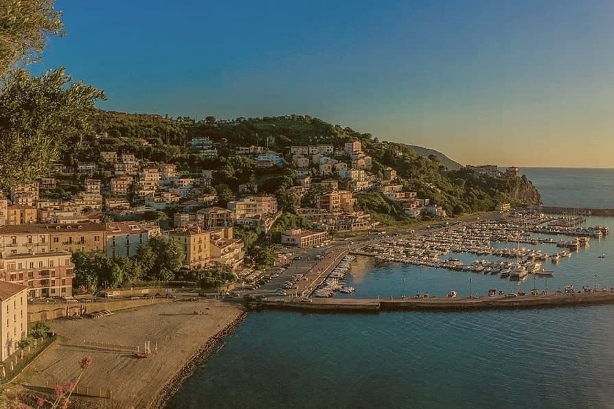
Agropoli is the northern gate of the Cilento coast, a promontory between two bays forty kilometres south of Salerno. The name itself, akropolis, was given by the Byzantines who fortified the high point during the Greco-Gothic war between 535 and 553.
In 882 the Saracens took the town and turned it into a rabat, a trenched stronghold from which they raided as far as the walls of Salerno until they were dislodged from the Garigliano camp in 915. The Angevin-Aragonese castle still stands on the highest point, a triangular plan with three circular towers and a moat, built on the original Byzantine foundations.
Below the castle, the centro storico runs in stone stairways down to the small fishing port. Modern Agropoli has 21,000 residents, a Bandiera Blu beach, the Spighe Verdi mark for agro-environmental quality, and Cilento National Park status that links it inland to the Mediterranean Diet biosphere.
We confirmed you can reach this one by train.
What to see in Agropoli
- Castello Angioino-Aragonese. Triangular castle with three circular towers and a moat, built on sixth-century Byzantine foundations and remodelled by the Angevins and Aragonese.
- Centro storico sul promontorio. Old town on the headland, stone stairways from the castle down to the fishing port, with the seventeenth-century Porta arch and tight whitewashed alleys.
- Chiesa dei Santi Pietro e Paolo. Sixteenth-century mother church inside the centro storico, rebuilt after war damage, dedicated to the patrons celebrated each 29 June.
How to get to Agropoli
There is a railway station in the town, so you can arrive without a car and never need one while you are here. Salerno is roughly 66 minutes away by road.
Our tip
May through September is the open Cilento beach season, with the marina filling up from late June onward and the Trentova bay reachable by foot or boat. July and August push the Cilento past thirty-five degrees and the port and headland fill with day boats from Capri and Salerno. April and October are dry and quieter, ideal for walking the castle path without the queue.
Capaccio Paestum
Why visit Capaccio Paestum
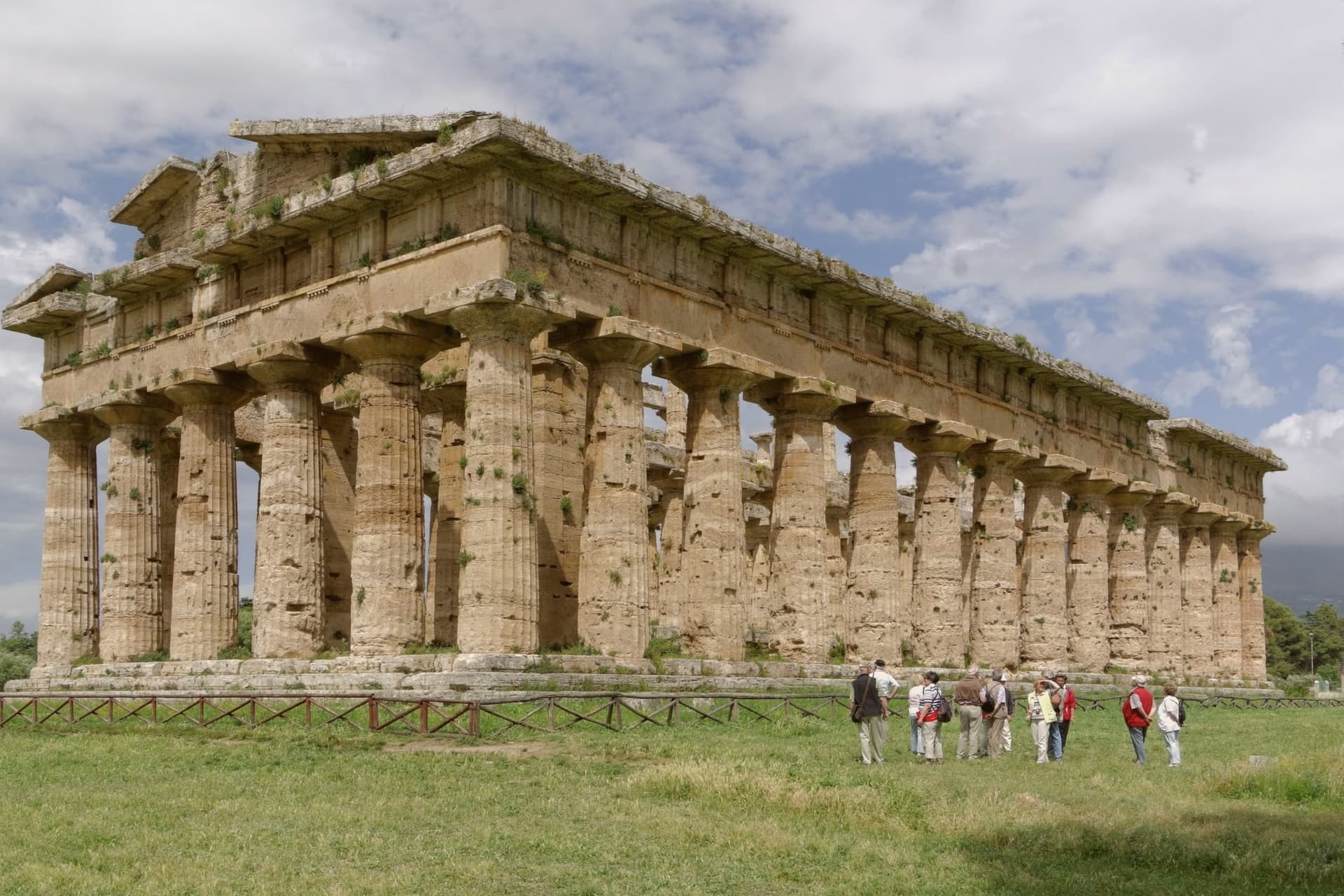
Capaccio Paestum is the only commune in Italy where the name pairs a medieval hilltown with an ancient city on the plain below. The seat of Capaccio sits at 419 meters on Monte Calpazio, while the archaeological park below, the city of Poseidonia founded around 600 BC, occupies the flat between the Sele river and the sea.
The two halves of the name mark two different settlements built centuries apart and never merged into one another. The layering below Monte Calpazio runs deeper than the founding city and the medieval hilltown: a Roman city followed the earlier one on the same plain, and the medieval Capaccio Vecchia, razed by Frederick II, was rebuilt as the hilltown that still carries the seat today.
The buffalo pastures that made the area's DOP mozzarella sit inside the same national park boundary as the Sele plain and the Monte Calpazio spur, so the cheese-making land and the ruins share one stretch of ground. The commune, in effect, is stacked: hill above, plain below, and each layer on the plain built over or beside the one before it.
We confirmed you can reach this one by train.
What to see in Capaccio Paestum
- Templi di Paestum. The Basilica, the Temple of Hera II and the Temple of Athena stand on the flat ground between the Sele river and the sea, close enough to walk between in an afternoon.
- Museo Archeologico Nazionale di Paestum. The frescoes are kept indoors, apart from the temples they were painted near, giving a rare look at how the tomb's painters depicted the afterlife.
- Mura greche di Paestum. Almost five kilometres of Greek and Roman defensive walls with four gates, intact across the entire perimeter of the ancient city.
How to get to Capaccio Paestum
There is a railway station in the town, so you can arrive without a car and never need one while you are here. Salerno is roughly 51 minutes away by road.
Our tip
May, June and September are the right months on the Sele plain, with the temples at sunrise or late afternoon and the buffalo pastures still green. July and August push the plain past thirty-eight degrees, the archaeological park closes its high noon hours and the beach absorbs most visitors. April and October are dry and quiet, the Madonna del Granato feast falls on the first Sunday of May and the temples are walkable without queues.
More from Anywhere Italy
- The best coastal towns inside a national park in Campania
- The best beach towns in the province of Salerno
- The best beach towns you can reach by train in Campania
 The best small towns you can reach by train in Campania
- The best towns with a serious restaurant that you can reach by train in Campania
- The best hidden beach towns in Campania