
Lombardy · Varese
Angera
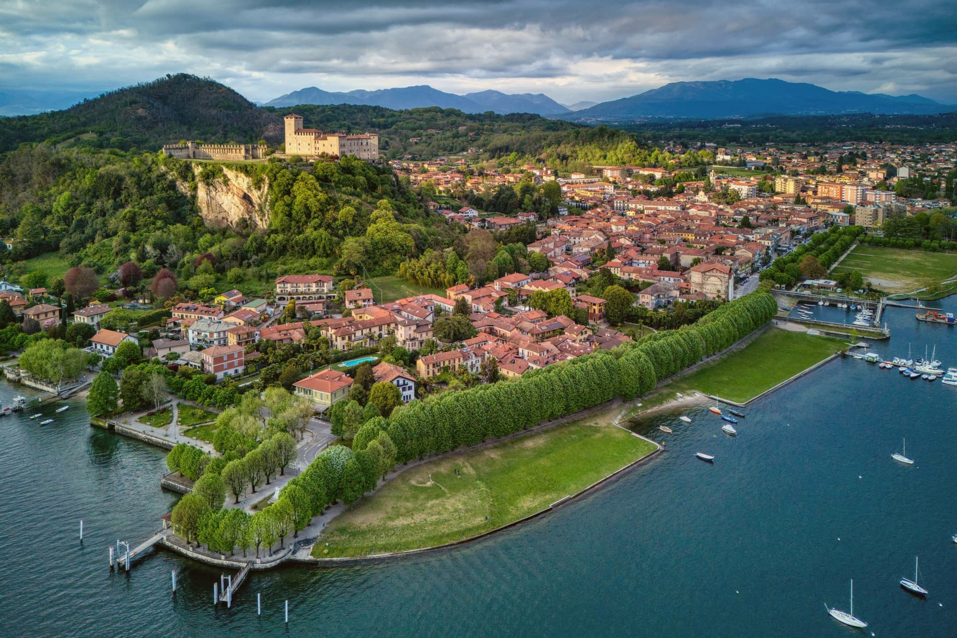
A Lake Maggiore town on the southern shore, anchored by a fortified castle on a limestone spur above the water, with a museum trail running from prehistory to the medieval period along the waterfront.
- Best time
- Apr–Oct
- By car
- 1 h from Milan
- Population
- 5,391
Known for
ROCCA
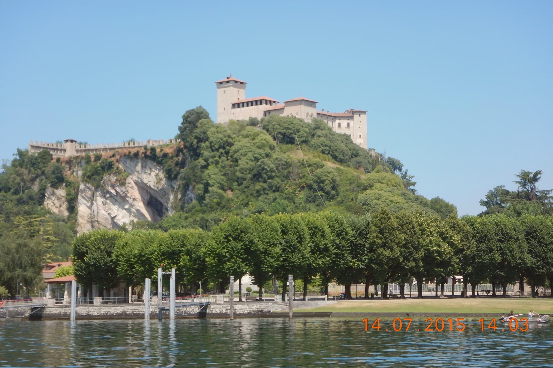
Rocca Borromea: 13th-century fortified castle, family seat since 1449, with a frescoed Justice Hall depicting the astrological theme of Archbishop Ottone Visconti's victory at Desio.
LAKE
Southern Lake Maggiore, quieter than Stresa, with ferry crossings to Arona and the Borromean islands.
PREHISTORY
Caves of Bògia and a documented prehistoric trail above the town, among the most documented in Lombardy.
When to visit
Best · Apr–Oct
- J9°
- F12°
- M14°
- A18°
- M21°
- J26°
- J29°
- A29°
- S24°
- O19°
- N13°
- D9°
- Best
- Hot or crowded
- Quiet
- Mostly closed
Daytime averages, 2020–2024. Weather data by Open-Meteo.com.
The festa: Maria Addolorata, 15 August
Why come
The town sits on the southern shore of Lake Maggiore, facing Arona directly across the water on the Piedmontese side. The two towns read as a pair, close enough that the crossing between them is a short ferry ride rather than a journey, and the view from the promenade is framed by that opposite shore as much as by the lake itself. The town's built order rises from the water: harbor and promenade at lake level, then the limestone bluffs behind them, then the castle on its spur above everything, with the Caves of Bògia cut into the same limestone the castle stands on.
The Rocca Borromea has belonged to the Borromeo family since 1449, and Justice Hall, inside it, holds one of the most important 13th-century fresco cycles in northern Italy. The Diocesan Museum and the Doll Museum occupy the same upper rooms, so the visit to the castle moves from religious art to costume dolls without leaving the building. What this adds up to is a single vertical town: prehistoric cliff, medieval seat, and lakefront strolling ground stacked on top of each other rather than spread apart, which is why the place reads as compact and walkable next to the crowds and day-trip traffic of the lake's better-known resorts, while still holding the same family's seat of power at its summit.
The Sunday letter
Angera is on our list. Its letter is still to come.
We are writing about all 1,000 of these towns, one at a time, in a free letter every Sunday: the photo, the food, the festa. That is our mission. Sign up and you will be there when Angera comes up. By Peter & Sophia, from Pietrasanta.
Read on
Angera in our articles
How to get there
From Milan (BGY), about 1h 27m by car.
Turin (TRN) is about 1h 43m away.
By car from the centre of Brescia 1h 50m.
Coming by train into Milano Centrale? Angera is about 1 hour away by road.
What to see
Rocca Borromea
The castle stands on a limestone spur with the lake below it on all approachable sides. Inside, the Sala della Giustizia is reached through a sequence of bare medieval rooms, so the fresco cycle opens without warning after plain stone.
Museo Diocesano + Doll Museum
Two collections share the castle's upper rooms: medieval religious art in one wing, a run of over a thousand antique dolls in period costume in the other. The contrast between the two, armor-adjacent stonework giving way to glass cases of costume dolls, is more jarring than either collection alone.
Lungolago di Angera
The promenade runs level along the water from the harbor to the base of the limestone bluffs, with the castle visible above for most of its length and open water toward the Piedmontese shore for the rest.
Caves of Bògia / prehistoric trail
The cliffs rise directly behind the promenade, and the finds recovered from them run from the Mesolithic through the Roman period, laid out along a marked trail rather than confined to a museum case.
The slow-trip planner
Building a trip? Find where Angera fits in a slow Italy circuit.
Answer five questions. We will shape a geographically coherent slow trip from the 1,000 Italian towns most travelers skip. Yours to save and share.
Living here
- Population 5,391
- In-betweeni
- Pharmacy in town
- High school within a 30-minute drive
- Nearest airport Milan, 1 h 27 min drive
- Regional capital Milano, 1 h 0 min drive
Common questions
- What is Angera known for?
- Angera is a Lake Maggiore town on the southern shore, anchored by a fortified castle on a limestone spur above the water, with a museum trail running from prehistory to the medieval period along the waterfront.
- Where is Angera?
- Angera is a comune in the province of Varese, in Lombardy, at 205 meters above sea level.
- What is the nearest airport to Angera?
- Milan (BGY), about 1h 27m by car.
- How long is the drive from Brescia to Angera?
- About 1h 50m by car.
- When is the best time to visit Angera?
- Best in Apr–Oct. August is the warmest month, averaging 29 degrees, and May the wettest, with about 16 rain days.
- Is there a sagra or a festival in Angera?
- The town keeps its patron saint's day: Maria Addolorata, 15 August.
- Which other towns are like Angera?
- Tremezzina, Bellagio and Menaggio.
- How many people live in Angera?
- 5,391 at the 2023 count.
Tags & datadesignations · numbers · sources
The numbers
- Elevation: 205 m
- Population: 5,391
- Surface area: 17.72 km²
These figures were compiled from public directories: ISTAT, OpenStreetMap and Wikidata, and from the official listings of the guides named on this page. Town details change; verify with official sources before you travel.
Similar
Towns like Angera
Tremezzina
Province: Como
both lake towns · both between 3,000 and 10,000 people
Bellagio
Province: Como
both lake towns · both between 3,000 and 10,000 people
Menaggio
Province: Como
both lake towns · both between 3,000 and 10,000 people
Cannobio
Province: Verbano-Cusio-Ossola
both lake towns · both between 3,000 and 10,000 people
Costermano sul Garda
Province: Verona
both lake towns · both between 3,000 and 10,000 people
Gozzano
Province: Novara
both lake towns · both between 3,000 and 10,000 people