
The best small towns inside a nature park that eat well in Liguria
Liguria is a thin strip of terraced land pressed between water and mountain, and most of what is good to eat here comes from that pressure. Basil grown low and small in the coastal glasshouses for pesto, chickpea flour cooked into farinata in copper pans, anchovies salted in the harbours, borage and wild herbs folded into pasta up in the hinterland. Inland, in the slate and stone villages of the Bormida and Stura valleys, the register shifts to chestnut flour, mushrooms, river fish and slow-cooked meat. The houses are painted plaster over stone, ochre and pink on the coast, bare grey slate the further you climb. Spring and late September are the good months, when the sea is still warm and the trattorie are not turning tables.
Almost everyone who comes to the Ligurian coast goes to the Cinque Terre, and the reason is plain enough: the five villages are spectacular, walkable end to end, and reachable by train from Genoa or La Spezia without a car. The consequence is equally plain. The Sentiero Azzurro queues in high summer, Vernazza's harbour fills by mid-morning, and the restaurants along the main lanes cook for people who will not be back.
The same coast and the same cooking carry on either side of it, and much of what continues is inside protected land. Liguria's regional nature parks cover headlands, wetlands at the mouth of the Magra, beech and chestnut forest behind Savona, and the ironworking valleys near the Piedmont border. The towns in this list all sit within one of those parks, and each has a table a dining guide has picked out. Fewer people go, and the kitchens are cooking mostly for the people who live there.
Of the 54 communes we have mapped in Liguria, 9 qualify as towns inside a nature park that eat well: each sits inside a regional nature park, and a dining guide has named a table in each. This list is the small ones, 6 in all, ordered smallest first. The smallest, Portofino, has 355 residents.
If you are still choosing, we have also written The best towns inside a nature park that eat well in Liguria and The best small towns inside a nature park in Liguria.
Campo Ligure
Why visit Campo Ligure
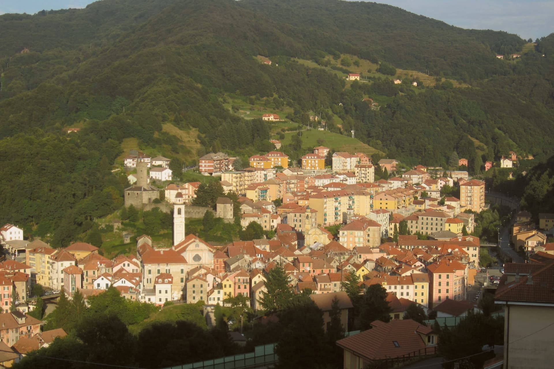
Campo Ligure sits on the right bank of the Stura at 342 meters, twenty-five kilometers north of Genoa where the Apennines start to climb. The Spinola family took the fief in the thirteenth century and built the hexagonal castle on the hill above the village; the cylindrical tower is more than twenty-two metres tall and six across.
The first filigree workshop opened in 1884. Within a generation Campo Ligure had become the national centre for the craft, fine gold and silver threads twisted with pliers called bruscelle and welded under a torch.
It remains the only working filigree centre in Italy. The Museo della Filigrana, founded in 1984 around the Pietro Carlo Bosio collection, holds filigree work from across the world.
A medieval stone bridge over the Stura, originally ninth-century and rebuilt several times from the eighteenth century onward, anchors the lower end of the borgo.
Caccia C’a Bugge, Caccia C'à Bugge have been named by a guide.
What to see in Campo Ligure
- Castello Spinola. Twelfth and thirteenth-century hexagonal fortress on the hill above the village, cylindrical tower 22 metres tall, residence of the Spinola fief.
- Museo della Filigrana Pietro Carlo Bosio. Founded 1984 around the Bosio collection, filigree work from across the world, the only museum of its kind in Italy.
- Ponte medievale sullo Stura. Stone bridge over the Stura with ninth-century origins, rebuilt several times from the eighteenth century, marks the southern entrance to the borgo.
How to get to Campo Ligure
There is a railway station in the town, so you can arrive without a car and never need one while you are here. Genova is roughly 41 minutes away by road.
Our tip
May through October is the working window: the Stura runs clear, the trail network up into the Parco del Beigua opens, the filigree workshops keep their doors open for visitors. The Mostra della Filigrana in late August is the year's main draw, three days of open studios and demonstrations. July and August can touch 30 degrees in the valley but the 342-metre elevation keeps evenings cool.
Millesimo
Why visit Millesimo
Millesimo sits sixty kilometers inland from Genoa, over the Apennine watershed, in the upper reaches of the valley that gives the wider area its name. Enrico II Del Carretto turned the village into a fortified borgo in 1206, and his successors raised the castle later in the same century on the high ground above the settlement.
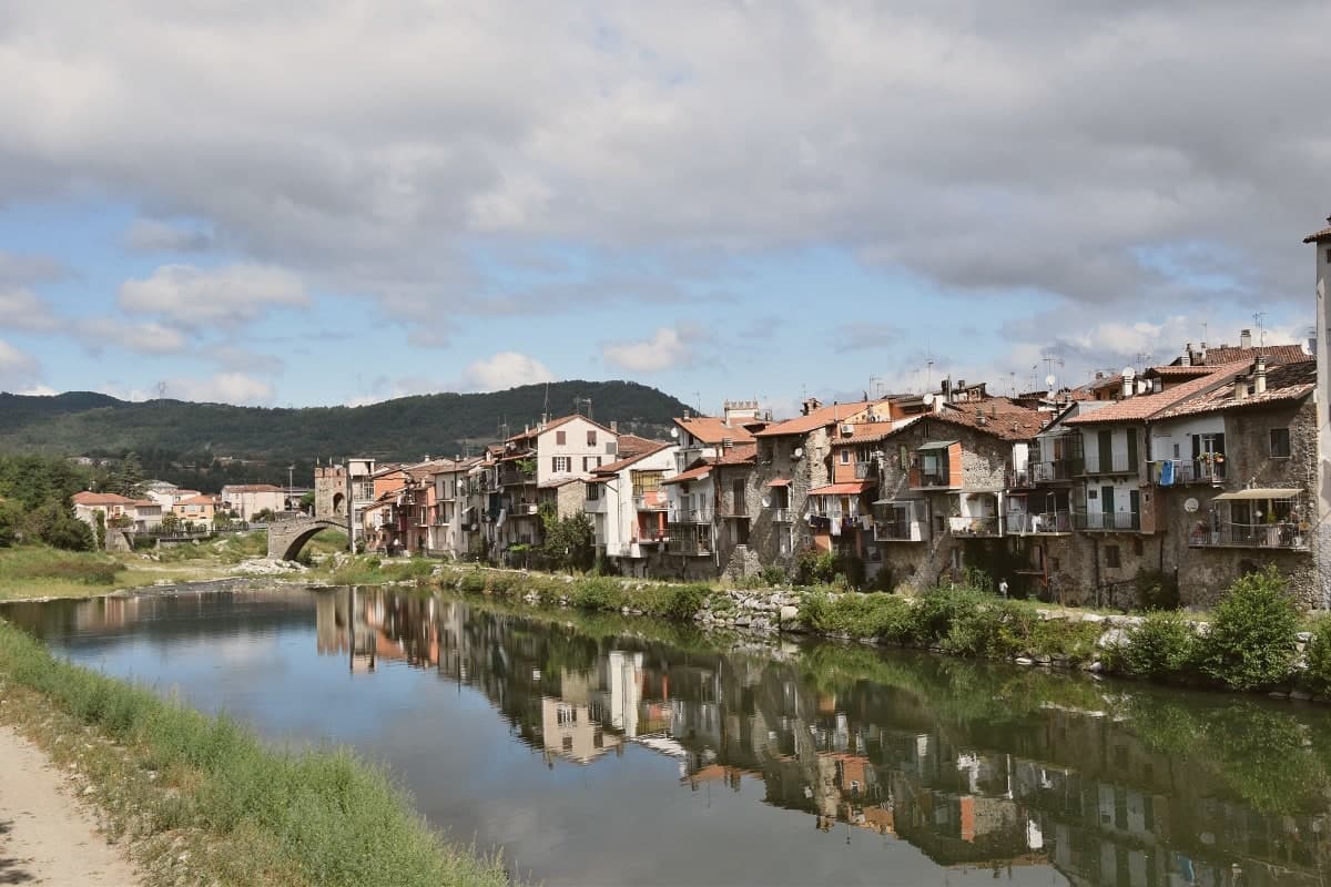
The town itself grew on the right bank of the river below that castle, its stone houses laid out in a triangle around the central piazza, with the fortified bridge carrying the crossing at the valley floor and the pilgrimage sanctuary set apart on the outskirts as the valley's separate religious focus. More than three thousand casualties fell on each side when Napoleon Bonaparte defeated the combined Austro-Sardinian forces here on 13-14 April 1796, directing the campaign from the Del Carretto palazzo on the piazza that now serves as the town hall.
The pattern is one of a small defensive settlement whose river crossing, castle and family seat all sit within sight of each other, later put to use for a battle whose scale had nothing to do with the size of the place that hosted it.
Locanda dell'Angelo have been named by a guide.
What to see in Millesimo
- Ponte della Gaietta. The old fortified body still spans the river below the village, narrow enough that its defensive purpose is obvious from either bank.
- Castello Del Carretto. Tower, keep and east wall stand above the village on the high ground, the stronghold that gave the marquis line command of the valley approach.
- Palazzo Del Carretto. The family palazzo faces the central piazza and now serves as the town hall, its rooms the setting for the 1796 headquarters rather than a battlefield relic.
How to get to Millesimo
Genova is roughly 73 minutes away by road.
Our tip
April through June and September through October are the dry months in the upper Val Bormida. The interior of Liguria runs cooler than the coast at this elevation, with mild days and chilly evenings; the rivers run higher in spring after the watershed melt. July and August warm up but Millesimo's 429 meters stay tolerable. XXXIV Festa nazionale del tartufo della Val Bormida a Millesimo falls in October.
Portofino
Why visit Portofino
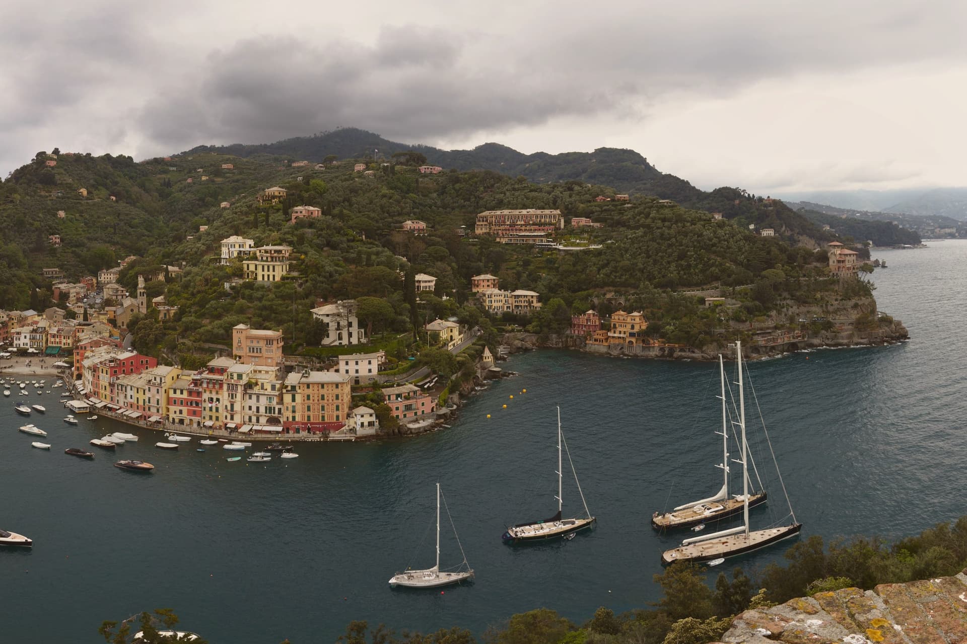
Portofino occupies the smallest municipal territory in the Metropolitan City of Genova, 355 residents on a horseshoe harbor on the southern tip of the Portofino headland. The whole commune sits inside the Portofino Regional Natural Park and the Portofino Protected Marine Area.
Roman fortification stood on the hill above the harbor; the medieval Genoese fort took the name Castello di San Giorgio, was later renamed Castello Brown after the British consul who bought it in 1867. British and then northern European aristocrats discovered the village in the late nineteenth century.
Aubrey Herbert and Elizabeth von Arnim were among the early regulars. By 1950 tourism had replaced fishing as the main industry.
The Chiesa di San Giorgio, first built in 1154 and destroyed by a wartime bomb, was rebuilt in 1950 on the 1760 plans. The painted facades around the harbor are the photograph everyone takes.
The footpaths into the park behind the village are the reason to stay longer than the cruise day-trippers.
Piazzetta di Portofino, Cracco Portofino, DaV Mare have been named by a guide.
What to see in Portofino
- Castello Brown. Genoese coastal fort raised over a Roman site, renamed in 1867 after British consul Montague Yeats Brown, now a historic house museum above the harbor.
- Chiesa di San Giorgio. Church first built in 1154, destroyed in Second World War bombing, rebuilt in 1950 on 1760 plans, on the path up to Castello Brown.
- Faro di Portofino. Lighthouse at the tip of the Portofino headland, walking distance from the harbor along the Punta del Capo coastal path.
How to get to Portofino
Genova is roughly 78 minutes away by road.
Our tip
May through June and September into October are the best months. The harbor is open, the park trails are dry, and the day-tripper rush from cruise ships is less intense than in midsummer. July and August fill the piazzetta from late morning to dusk, the ferry queues from Santa Margherita stretch to the seafront, and parking is closed to outside cars.
Portovenere
Why visit Portovenere
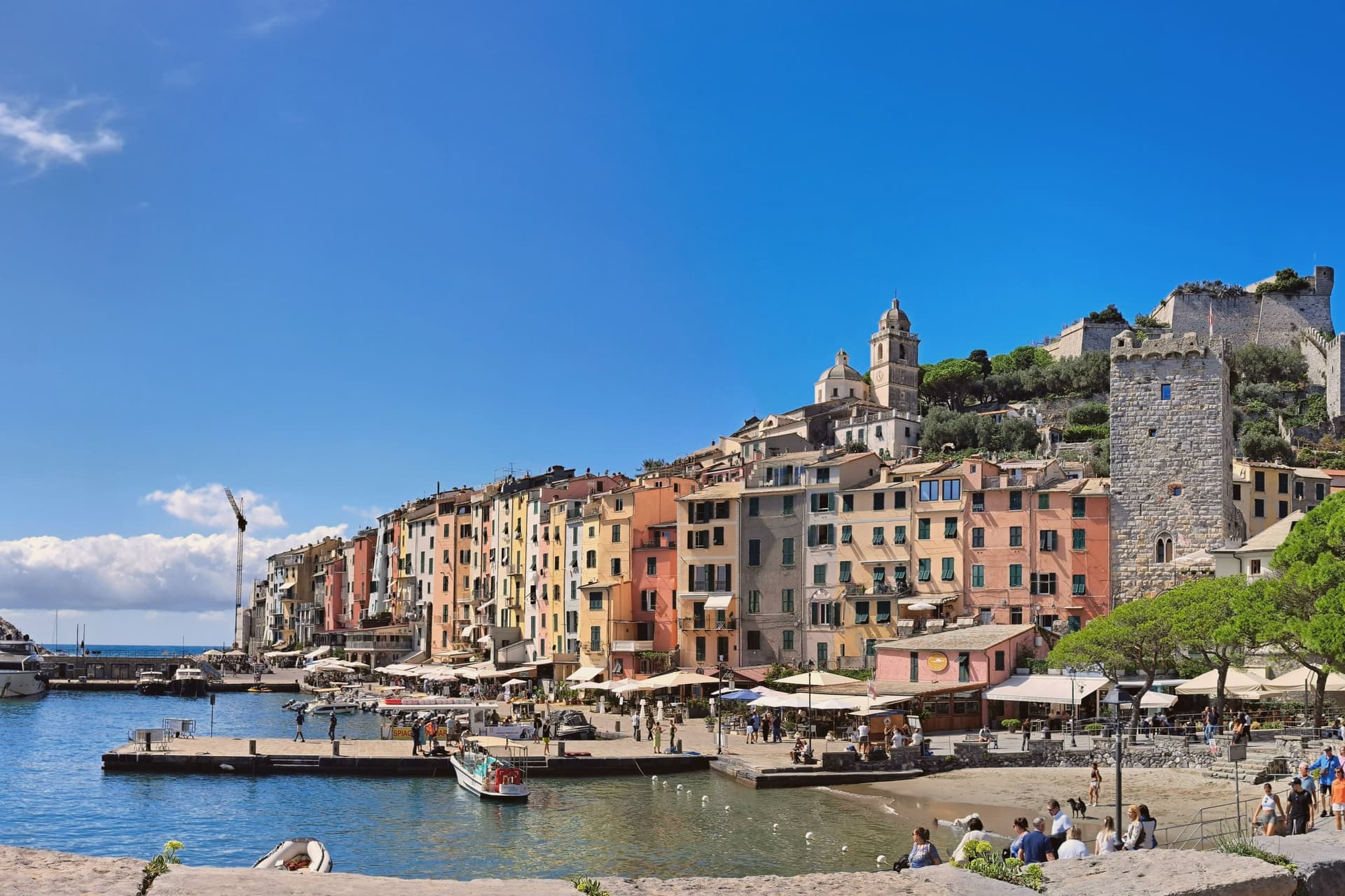
Portovenere closes the western mouth of the Gulf of La Spezia, three kilometers south of the city by water, facing the islands of Palmaria, Tino and Tinetto across open water. The Roman Portus Veneris dates to at least the first century BC, named for a temple to Venus on the promontory that now carries the striped church at the harbour mouth.
Genoa took control in 1113 and fortified the town as the southern anchor of its Riviera defences, opposite Pisan Lerici across the gulf: the fortress above the harbour and the church on the rock were built to face each other's rival coast rather than each other. The upper town holds the castle and its Romanesque parish church, rebuilt after a fire in 1340 damaged that quarter; the single medieval street below runs parallel to the harbour, its plan unchanged since Genoa first laid the town out in the twelfth century.
The promontory church stands apart from both, reachable along the water's edge, with the sea cave that took Byron's name cut into the rock beneath it. A fortified street, a hilltop castle and a temple site turned church: the town reads as a defensive line built along a single spine of rock, with the gulf doing the rest of the work UNESCO recognized in 1997.
Tre Torri, Ristorante Portivene have been named by a guide.
What to see in Portovenere
- Chiesa di San Pietro. Consecrated 1198, black and white striped Gothic rebuild from 1256-1277, on the rocky promontory where the Roman temple of Venus stood.
- Castello Doria. First cited 1139, rebuilt 1161, expanded into the seventeenth century, the Genoese fortress above the harbour, prison under Napoleonic rule.
- Grotta dell'Arpaia. Sea cave below San Pietro, also called Byron's Grotto for the English poet who swam from here to Lerici across the gulf to visit Shelley.
How to get to Portovenere
Pisa is roughly 83 minutes away by road.
✷ We have written about Portovenere
“Most people spend a few hours in Portovenere between the ferry and the aperitivo. We gave it three weeks, and the town we got was the one the couple on the balcony lived in: vertical, repetitive, almost monastic, a town where the day is a staircase you climb the same way at the same hours, where the luxuries are a balcony the size of a doormat and an espresso stretched to thirty minutes because there is no reason on earth to drink it faster.”
Read our piece on Portovenere →Portovenere | The Slowest Coffee in Italy
Our tip
April through June and September to October are the working windows. Ferries to Palmaria run on full schedules from May onwards; the gulf is calm enough to swim by late May. July and August fill the carruggio and the Castello Doria, accommodation runs at three times shoulder rates, and the queue for the climb to San Pietro can reach an hour. Sagra Pansa E Stacca falls in June.
Ameglia
Why visit Ameglia
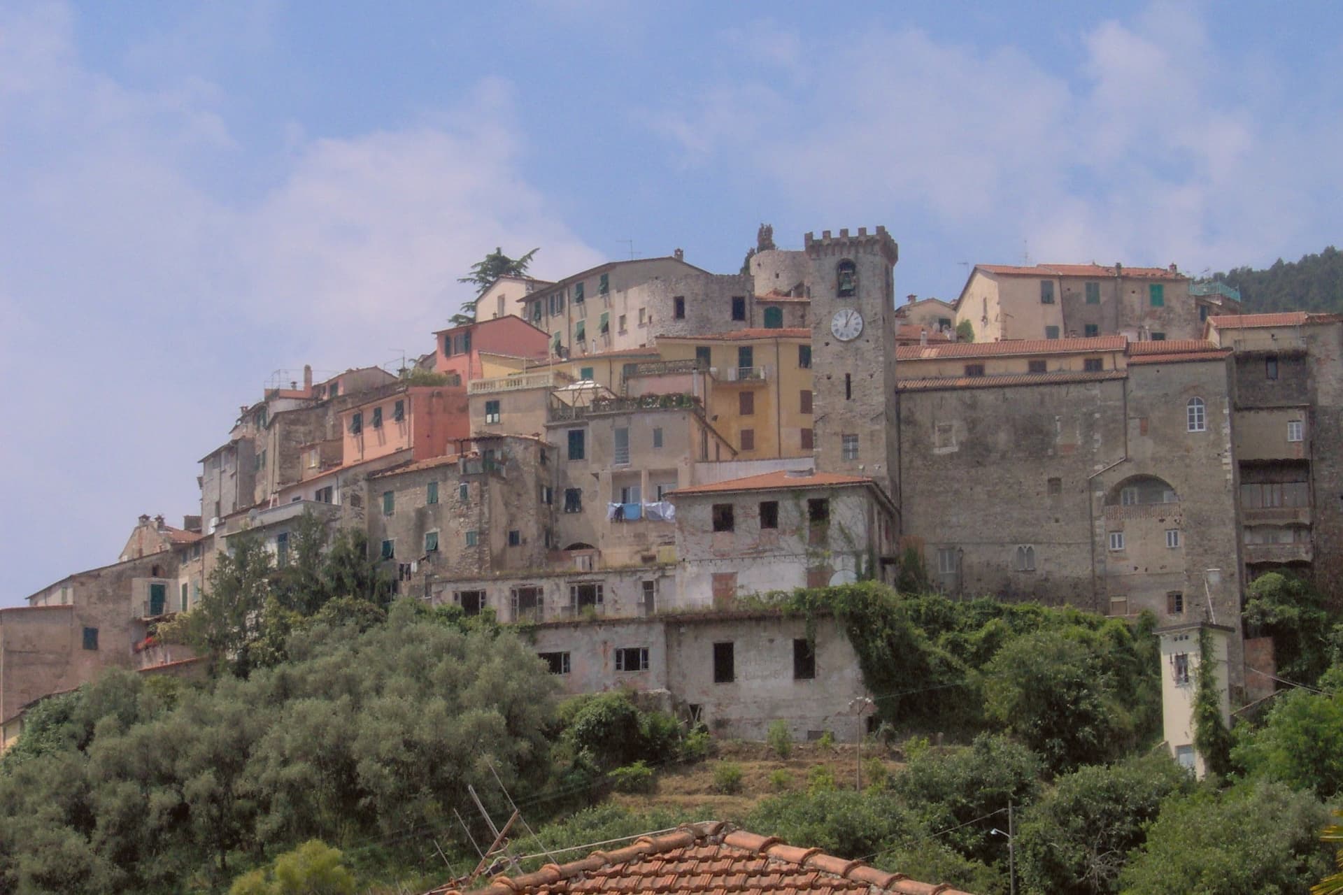
The Magra was the Roman Macra, the eastern boundary of Liguria, and the hill at Ameglia stands on the border between Lunigiana and the Riviera where that river reaches the sea. Genoa bought part of the fief in 1141, the bishops took it back by 1284, and Castruccio Castracani of Lucca conquered it in 1321: a small fortress passed between larger powers for three and a half centuries before it settled into the shape it now has.
The marina at the river mouth is a separate world from the hill town above it. Where the castle and its concentric streets sit on the summit, the frazione at the water is a former fishing village, flat, tied to the tide and to summer moorings rather than to the bishops who once held the heights.
The two headlands south of that marina are reachable only by boat or steep footpath, cut off from the estuary settlement by their own geography rather than by distance. The town, in effect, is two places joined by the same river: a fortified height that answered to Luni and Genoa, and a working shoreline that answered to the sea.
Pescarino-Sapori di Terra e di Mare, LUV Ristorante have been named by a guide.
What to see in Ameglia
- Castello di Ameglia. Rebuilt in 1174 on a tenth-century footprint, episcopal fortress of the bishops of Luni, cylindrical keep above the Magra estuary.
- Centro storico di Ameglia. Concentric medieval streets around the castle, twelfth and thirteenth-century houses with stone arches and external staircases.
- Bocca di Magra. Old fishing village and marina at the river mouth, summer mooring for small craft, departure point for Punta Corvo by sea.
How to get to Ameglia
Pisa is roughly 60 minutes away by road.
✷ We have written about Ameglia
“It has the best panorama in Liguria, full stop, and I do not think it is close. The reasons are two. The first is the obvious one. You are 266 meters up, the cliff is high enough that there is no rocky beach below to draw a crowd, the sea on one side is the Gulf of La Spezia with Portovenere across the water and the Cinque Terre fading north, and the view on the other side is the Magra running into its delta with the white Apuane behind it and Tuscany beyond.”
Read our piece on Ameglia →Magra Delta Roadtrip | A Tagine, a Lighthouse, and a Dead Roman City
Our tip
April through June and September to October bring the river's best months: clear estuary water, the headland walks down to Punta Corvo manageable, marinas at Bocca di Magra not yet at summer capacity. July and August fill the river mouth with summer boats from across the Gulf of Poets, and the road down from the borgo backs up on weekends. The Sagra del Pesce in mid-August draws thousands. Mercato Settimanale Di Ameglia falls in August.
Camogli
Why visit Camogli
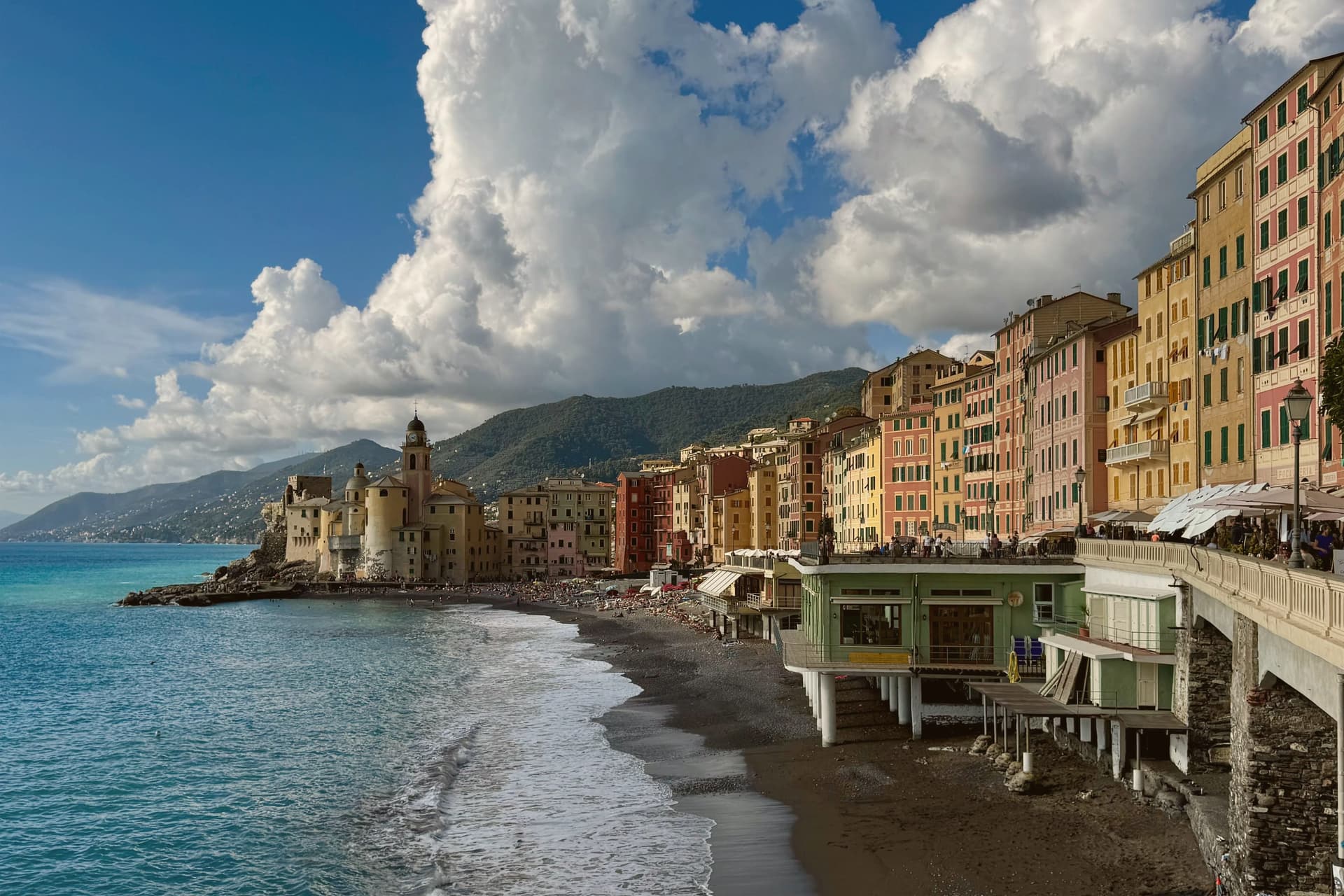
Camogli sits on the west side of the Portofino peninsula, twenty kilometers from Genova on the Golfo Paradiso. The earliest record dates to the tenth century, when it was already a tuna and shrimp fishing port.
By the nineteenth century, the town's fleet of merchant sailing ships ran to several hundred vessels and Camogli was called the city of a thousand white sails. After the naval defeat at Abukir against the British, the camogliesi shipowners reinvested in building merchant sailers under contract to the major European states.
The painted façades of the seafront houses, with their false windows and trompe-l'oeil cornices, served the returning sailors as recognition marks from sea. The Castello della Dragonara, built in the thirteenth century, still guards the harbor.
Every second Sunday of May, the Sagra del Pesce fries thirty thousand portions of fish in a single giant pan on the wharf, in honor of San Fortunato. San Fruttuoso, the eleventh-century abbey reachable by boat or trail, sits in the next cove.
La Loggia have been named by a guide.
What to see in Camogli
- Castello della Dragonara. Thirteenth-century fortress guarding the harbor, used as municipal seat and now a venue for exhibitions and cultural events.
- Basilica di Santa Maria Assunta. Parish basilica next to the castle on the harbor, baroque interior with marble inlays and seventeenth-century paintings.
- Abbazia di San Fruttuoso. Eleventh-century Benedictine abbey in the next cove, reachable by boat or by the coastal trail across the Portofino peninsula.
How to get to Camogli
There is a railway station in the town, so you can arrive without a car and never need one while you are here. Genova is roughly 33 minutes away by road.
✷ We have written about Camogli
“A steep hill falls into the sea. The houses are crammed on the slope and painted in bright colors because they are old, packed tight, and need help. There is a small port if the cove allows it and a bigger port if the cove is generous. There is a small piazza around a small church, with maybe four restaurants, three bars, and a gelato place. There is no space for a grand square, because there is no space for grand anything in Liguria.”
Read our piece on Camogli →Tigullio Roadtrip | Four Versions of the Same Liguria
Our tip
April through June and September into October are the strongest months for the Camogli seafront, with mild evenings and clean water before the Genova weekend traffic peaks. The Sagra del Pesce on the second Sunday of May is the date that fills the wharf. July and August are warm, often 28 to 30 degrees, and the painted-façade harbor fills with day-trippers off the Genova trains. Sagra Del Pesce falls in May.
More from Anywhere Italy
- The best towns inside a nature park that eat well in Liguria
 The best small towns inside a nature park in Liguria
 The best coastal towns inside a nature park in Liguria
 The prettiest small villages that eat well in Liguria
- The prettiest villages inside a nature park in Liguria
- The best towns inside a nature park that have a serious restaurant in Liguria